You are here: Home > Network List > US - United States National Seismic Network Stations List
> Station DGMT Dagmar, Montana, USA > Earthquake Result Viewer
DGMT Dagmar, Montana, USA - Earthquake Result Viewer
| Earthquake location: |
Near Coast Of Chiapas, Mexico |
| Earthquake latitude/longitude: |
15.9/-93.4 |
| Earthquake time(UTC): |
2015/12/17 (351) 19:49:54 GMT |
| Earthquake Depth: |
97 km |
| Earthquake Magnitude: |
6.4 MWB, 6.6 MI |
| Earthquake Catalog/Contributor: |
NEIC PDE/NEIC COMCAT |
|
| Network: |
US United States National Seismic Network |
| Station: |
DGMT Dagmar, Montana, USA |
| Lat/Lon: |
48.47 N/104.20 W |
| Elevation: |
0.0 m |
|
| Distance: |
33.7 deg |
| Az: |
347.043 deg |
| Baz: |
161.083 deg |
| Ray Param: |
0.07783053 |
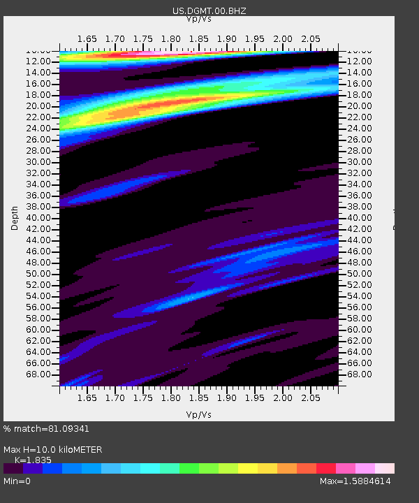
| Estimated Moho Depth: |
10.0 km |
| Estimated Crust Vp/Vs: |
1.84 |
| Assumed Crust Vp: |
6.438 km/s |
| Estimated Crust Vs: |
3.508 km/s |
| Estimated Crust Poisson's Ratio: |
0.29 |
|
| Radial Match: |
81.09341 % |
| Radial Bump: |
361 |
| Transverse Match: |
49.229797 % |
| Transverse Bump: |
400 |
| SOD ConfigId: |
7422571 |
| Insert Time: |
2019-04-21 14:42:55.830 +0000 |
| GWidth: |
2.5 |
| Max Bumps: |
400 |
| Tol: |
0.001 |
|
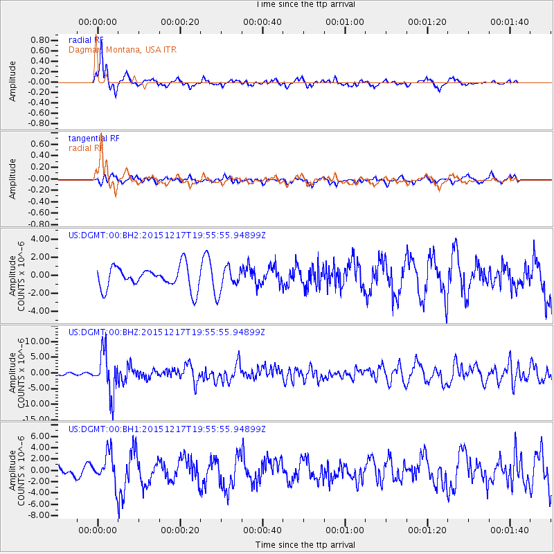
Signal To Noise
| Channel | StoN | STA | LTA |
| US:DGMT:00:BHZ:20151217T19:55:55.94899Z | 15.368118 | 6.7610604E-6 | 4.399407E-7 |
| US:DGMT:00:BH1:20151217T19:55:55.94899Z | 2.4798257 | 2.8030233E-6 | 1.1303307E-6 |
| US:DGMT:00:BH2:20151217T19:55:55.94899Z | 0.9684925 | 1.1697351E-6 | 1.2077896E-6 |
| Arrivals |
| Ps | 1.4 SECOND |
| PpPs | 4.1 SECOND |
| PsPs/PpSs | 5.5 SECOND |


