You are here: Home > Network List > CI - Caltech Regional Seismic Network Stations List
> Station VES Vestal, Richgrove, CA, USA > Earthquake Result Viewer
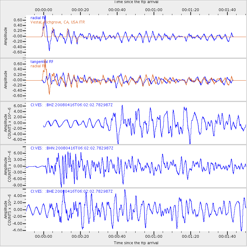
VES Vestal, Richgrove, CA, USA - Earthquake Result Viewer
| Earthquake location: |
Andreanof Islands, Aleutian Is. |
| Earthquake latitude/longitude: |
51.9/-179.2 |
| Earthquake time(UTC): |
2008/04/16 (107) 05:54:19 GMT |
| Earthquake Depth: |
13 km |
| Earthquake Magnitude: |
6.1 MB, 6.5 MS, 6.6 MW, 6.6 MW |
| Earthquake Catalog/Contributor: |
WHDF/NEIC |
|
| Network: |
CI Caltech Regional Seismic Network |
| Station: |
VES Vestal, Richgrove, CA, USA |
| Lat/Lon: |
35.84 N/119.08 W |
| Elevation: |
154 m |
|
| Distance: |
44.9 deg |
| Az: |
86.476 deg |
| Baz: |
310.403 deg |
| Ray Param: |
0.07164035 |
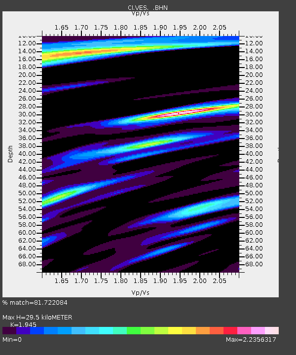
| Estimated Moho Depth: |
29.5 km |
| Estimated Crust Vp/Vs: |
1.95 |
| Assumed Crust Vp: |
6.1 km/s |
| Estimated Crust Vs: |
3.136 km/s |
| Estimated Crust Poisson's Ratio: |
0.32 |
|
| Radial Match: |
81.722084 % |
| Radial Bump: |
353 |
| Transverse Match: |
70.94593 % |
| Transverse Bump: |
378 |
| SOD ConfigId: |
2504 |
| Insert Time: |
2010-02-26 00:01:17.584 +0000 |
| GWidth: |
2.5 |
| Max Bumps: |
400 |
| Tol: |
0.001 |
|
Signal To Noise
| Channel | StoN | STA | LTA |
| CI:VES: :BHN:20080416T06:02:02.782987Z | 7.9145384 | 1.6221044E-6 | 2.049525E-7 |
| CI:VES: :BHE:20080416T06:02:02.782987Z | 1.4912096 | 1.3098712E-6 | 8.7839516E-7 |
| CI:VES: :BHZ:20080416T06:02:02.782987Z | 1.3954744 | 1.1785246E-6 | 8.4453325E-7 |
| Arrivals |
| Ps | 4.8 SECOND |
| PpPs | 14 SECOND |
| PsPs/PpSs | 18 SECOND |


