You are here: Home > Network List > UW - Pacific Northwest Regional Seismic Network Stations List
> Station WOLL Wollman Farm, Schrag, WA, USA > Earthquake Result Viewer
WOLL Wollman Farm, Schrag, WA, USA - Earthquake Result Viewer
| Earthquake location: |
Near Coast Of Chiapas, Mexico |
| Earthquake latitude/longitude: |
15.9/-93.4 |
| Earthquake time(UTC): |
2015/12/17 (351) 19:49:54 GMT |
| Earthquake Depth: |
97 km |
| Earthquake Magnitude: |
6.4 MWB, 6.6 MI |
| Earthquake Catalog/Contributor: |
NEIC PDE/NEIC COMCAT |
|
| Network: |
UW Pacific Northwest Regional Seismic Network |
| Station: |
WOLL Wollman Farm, Schrag, WA, USA |
| Lat/Lon: |
47.06 N/118.92 W |
| Elevation: |
385 m |
|
| Distance: |
37.6 deg |
| Az: |
331.155 deg |
| Baz: |
137.236 deg |
| Ray Param: |
0.07573057 |
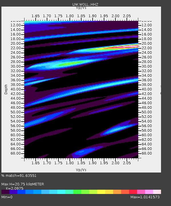
| Estimated Moho Depth: |
20.75 km |
| Estimated Crust Vp/Vs: |
2.10 |
| Assumed Crust Vp: |
6.419 km/s |
| Estimated Crust Vs: |
3.06 km/s |
| Estimated Crust Poisson's Ratio: |
0.35 |
|
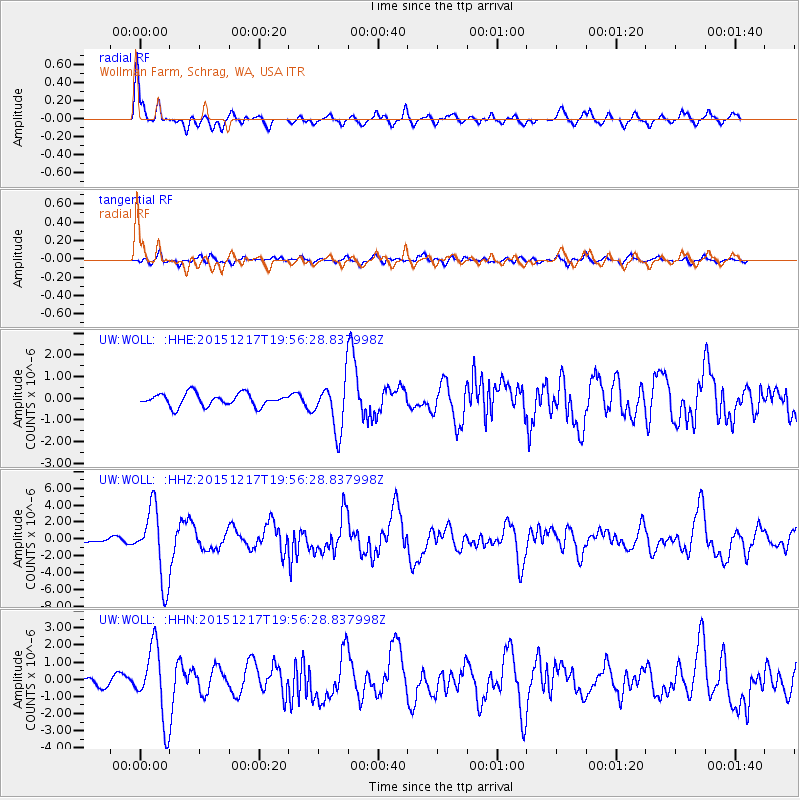
| Radial Match: |
91.63551 % |
| Radial Bump: |
400 |
| Transverse Match: |
75.96445 % |
| Transverse Bump: |
400 |
| SOD ConfigId: |
7422571 |
| Insert Time: |
2019-04-21 14:43:23.847 +0000 |
| GWidth: |
2.5 |
| Max Bumps: |
400 |
| Tol: |
0.001 |
|
Signal To Noise
| Channel | StoN | STA | LTA |
| UW:WOLL: :HHZ:20151217T19:56:28.837998Z | 10.093874 | 4.3108716E-6 | 4.27078E-7 |
| UW:WOLL: :HHN:20151217T19:56:28.837998Z | 7.730758 | 2.1353424E-6 | 2.7621385E-7 |
| UW:WOLL: :HHE:20151217T19:56:28.837998Z | 5.3716063 | 1.5650785E-6 | 2.9136135E-7 |
| Arrivals |
| Ps | 3.8 SECOND |
| PpPs | 9.4 SECOND |
| PsPs/PpSs | 13 SECOND |


