You are here: Home > Network List > WU - The Southern Ontario Seismic Network Stations List
> Station BMRO Meriville Lake, Ontario, Canada > Earthquake Result Viewer
BMRO Meriville Lake, Ontario, Canada - Earthquake Result Viewer
| Earthquake location: |
Near Coast Of Chiapas, Mexico |
| Earthquake latitude/longitude: |
15.9/-93.4 |
| Earthquake time(UTC): |
2015/12/17 (351) 19:49:54 GMT |
| Earthquake Depth: |
97 km |
| Earthquake Magnitude: |
6.4 MWB, 6.6 MI |
| Earthquake Catalog/Contributor: |
NEIC PDE/NEIC COMCAT |
|
| Network: |
WU The Southern Ontario Seismic Network |
| Station: |
BMRO Meriville Lake, Ontario, Canada |
| Lat/Lon: |
44.60 N/81.22 W |
| Elevation: |
217 m |
|
| Distance: |
30.4 deg |
| Az: |
17.365 deg |
| Baz: |
203.702 deg |
| Ray Param: |
0.079178415 |
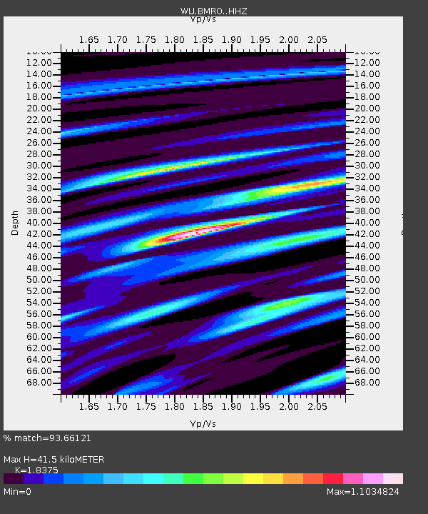
| Estimated Moho Depth: |
41.5 km |
| Estimated Crust Vp/Vs: |
1.84 |
| Assumed Crust Vp: |
6.53 km/s |
| Estimated Crust Vs: |
3.554 km/s |
| Estimated Crust Poisson's Ratio: |
0.29 |
|
| Radial Match: |
93.66121 % |
| Radial Bump: |
288 |
| Transverse Match: |
79.38961 % |
| Transverse Bump: |
400 |
| SOD ConfigId: |
7422571 |
| Insert Time: |
2019-04-21 14:43:30.285 +0000 |
| GWidth: |
2.5 |
| Max Bumps: |
400 |
| Tol: |
0.001 |
|

Signal To Noise
| Channel | StoN | STA | LTA |
| WU:BMRO: :HHZ:20151217T19:55:28.439988Z | 7.6471777 | 2.9896162E-6 | 3.9094374E-7 |
| WU:BMRO: :HHN:20151217T19:55:28.439988Z | 9.203571 | 2.097595E-6 | 2.2791096E-7 |
| WU:BMRO: :HHE:20151217T19:55:28.439988Z | 4.6857514 | 1.1575389E-6 | 2.4703377E-7 |
| Arrivals |
| Ps | 5.8 SECOND |
| PpPs | 17 SECOND |
| PsPs/PpSs | 22 SECOND |


