You are here: Home > Network List > CI - Caltech Regional Seismic Network Stations List
> Station VES Vestal, Richgrove, CA, USA > Earthquake Result Viewer
VES Vestal, Richgrove, CA, USA - Earthquake Result Viewer
| Earthquake location: |
Loyalty Islands |
| Earthquake latitude/longitude: |
-20.3/168.8 |
| Earthquake time(UTC): |
2008/04/19 (110) 05:58:42 GMT |
| Earthquake Depth: |
14 km |
| Earthquake Magnitude: |
5.7 MB, 6.2 MS, 6.3 MW, 6.2 MW |
| Earthquake Catalog/Contributor: |
WHDF/NEIC |
|
| Network: |
CI Caltech Regional Seismic Network |
| Station: |
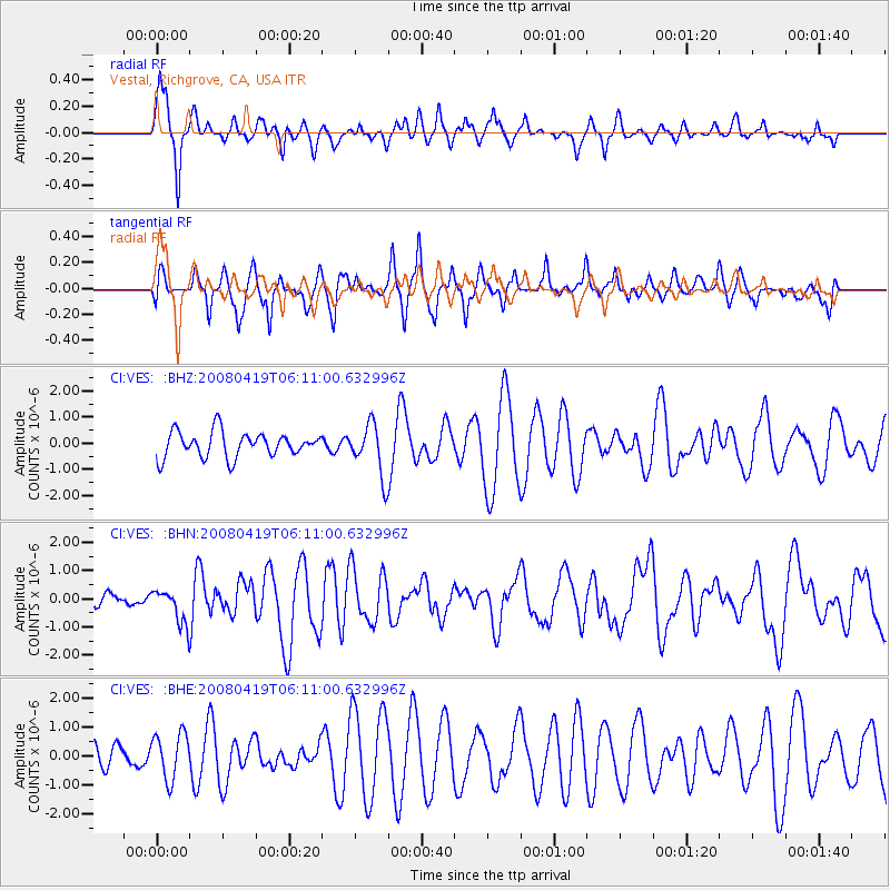
VES Vestal, Richgrove, CA, USA |
| Lat/Lon: |
35.84 N/119.08 W |
| Elevation: |
154 m |
|
| Distance: |
88.1 deg |
| Az: |
50.687 deg |
| Baz: |
243.375 deg |
| Ray Param: |
0.04284161 |
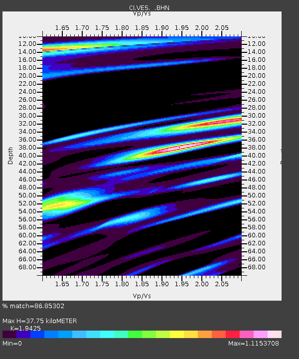
| Estimated Moho Depth: |
37.75 km |
| Estimated Crust Vp/Vs: |
1.94 |
| Assumed Crust Vp: |
6.1 km/s |
| Estimated Crust Vs: |
3.14 km/s |
| Estimated Crust Poisson's Ratio: |
0.32 |
|
| Radial Match: |
86.85302 % |
| Radial Bump: |
323 |
| Transverse Match: |
68.04368 % |
| Transverse Bump: |
371 |
| SOD ConfigId: |
2504 |
| Insert Time: |
2010-02-26 00:01:19.865 +0000 |
| GWidth: |
2.5 |
| Max Bumps: |
400 |
| Tol: |
0.001 |
|
Signal To Noise
| Channel | StoN | STA | LTA |
| CI:VES: :BHN:20080419T06:11:00.632996Z | 3.7686253 | 6.0698846E-7 | 1.6106362E-7 |
| CI:VES: :BHE:20080419T06:11:00.632996Z | 1.5080264 | 7.9627443E-7 | 5.280242E-7 |
| CI:VES: :BHZ:20080419T06:11:00.632996Z | 2.0515761 | 9.873693E-7 | 4.812735E-7 |
| Arrivals |
| Ps | 5.9 SECOND |
| PpPs | 18 SECOND |
| PsPs/PpSs | 24 SECOND |


