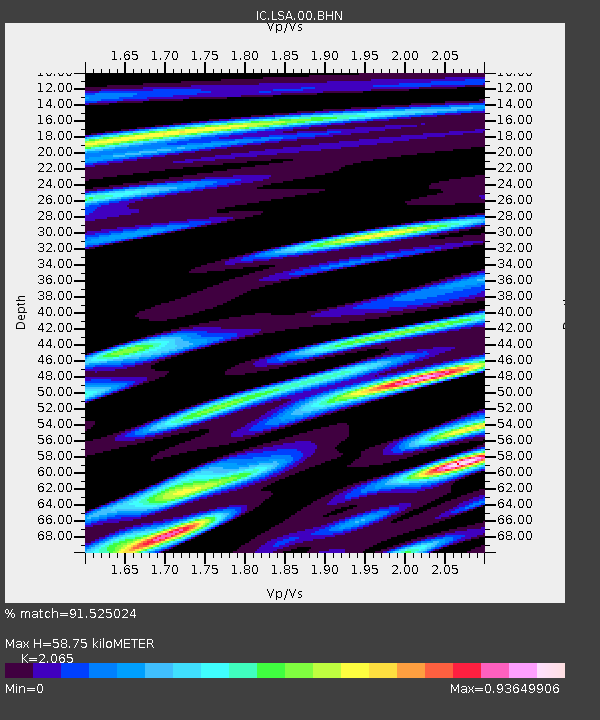
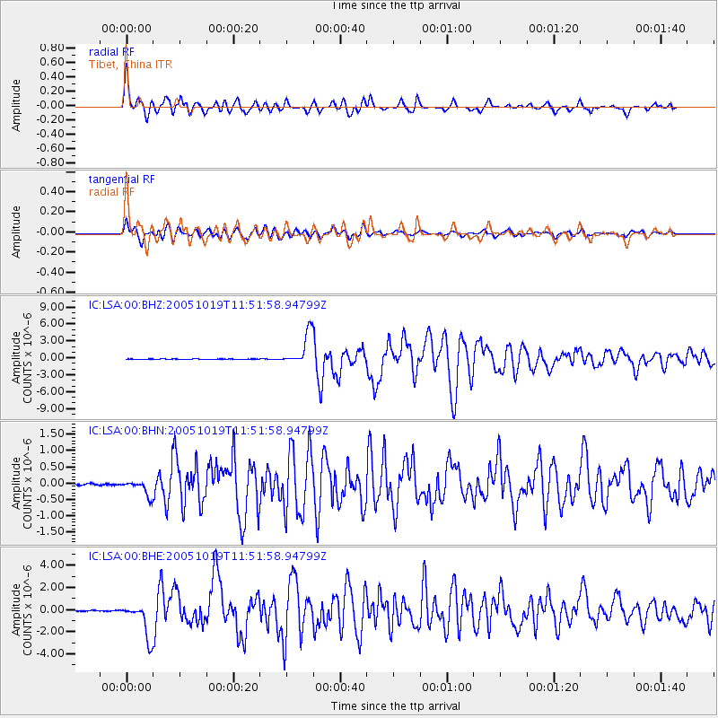
LSA Tibet, China - Earthquake Result Viewer

Earthquake location: Near East Coast Of Honshu, Japan
Earthquake latitude/longitude: 36.4/140.8
Earthquake time(UTC): 2005/10/19 (292) 11:44:42 GMT
Earthquake Depth: 32 km
Earthquake Magnitude: 6.2 MB, 6.5 MS, 6.4 MW, 6.3 MW
Earthquake Catalog/Contributor: WHDF/NEIC
Network: IC New China Digital Seismograph Network
Station: LSA Tibet, China
Lat/Lon: 29.70 N/91.15 E
Elevation: 3789 m
Distance: 41.8 deg
Az: 275.602 deg
Baz: 67.339 deg
Ray Param: 0.073491916
Estimated Moho Depth: 58.75 km
Estimated Crust Vp/Vs: 2.07
Assumed Crust Vp: 6.514 km/s
Estimated Crust Vs: 3.155 km/s
Estimated Crust Poisson's Ratio: 0.35
Radial Match: 91.525024 %
Radial Bump: 400
Transverse Match: 84.62626 %
Transverse Bump: 400
SOD ConfigId: 2475
Insert Time: 2010-03-04 22:46:39.482 +0000
GWidth: 2.5
Max Bumps: 400
Tol: 0.001

Signal To Noise

ChannelStoNSTALTA
IC:LSA:00:BHN:20051019T11:51:58.94799Z10.5298952.4270017E-72.304868E-8
IC:LSA:00:BHE:20051019T11:51:58.94799Z38.4956131.634133E-64.2449848E-8
IC:LSA:00:BHZ:20051019T11:51:58.94799Z67.393262.9506386E-64.3782403E-8
Arrivals
Ps10 SECOND
PpPs26 SECOND
PsPs/PpSs36 SECOND