You are here: Home > Network List > XD14 - Illuminating the architecture of the greater Mount St. Helens magmatic systems f Stations List
> Station MP06 "Mount St Helens, WA" > Earthquake Result Viewer
MP06 "Mount St Helens, WA" - Earthquake Result Viewer
| Earthquake location: |
Near Coast Of Chiapas, Mexico |
| Earthquake latitude/longitude: |
15.9/-93.4 |
| Earthquake time(UTC): |
2015/12/17 (351) 19:49:54 GMT |
| Earthquake Depth: |
97 km |
| Earthquake Magnitude: |
6.4 MWB, 6.6 MI |
| Earthquake Catalog/Contributor: |
NEIC PDE/NEIC COMCAT |
|
| Network: |
XD Illuminating the architecture of the greater Mount St. Helens magmatic systems f |
| Station: |
MP06 "Mount St Helens, WA" |
| Lat/Lon: |
45.83 N/122.20 W |
| Elevation: |
796 m |
|
| Distance: |
38.3 deg |
| Az: |
327.154 deg |
| Baz: |
131.715 deg |
| Ray Param: |
0.075295955 |
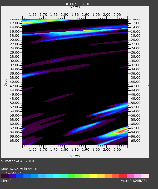
| Estimated Moho Depth: |
62.75 km |
| Estimated Crust Vp/Vs: |
2.10 |
| Assumed Crust Vp: |
6.566 km/s |
| Estimated Crust Vs: |
3.13 km/s |
| Estimated Crust Poisson's Ratio: |
0.35 |
|
| Radial Match: |
84.37019 % |
| Radial Bump: |
400 |
| Transverse Match: |
37.37109 % |
| Transverse Bump: |
400 |
| SOD ConfigId: |
7422571 |
| Insert Time: |
2019-04-21 14:44:26.971 +0000 |
| GWidth: |
2.5 |
| Max Bumps: |
400 |
| Tol: |
0.001 |
|

Signal To Noise
| Channel | StoN | STA | LTA |
| XD:MP06: :BHZ:20151217T19:56:35.085007Z | 6.9151287 | 3.111459E-6 | 4.4994954E-7 |
| XD:MP06: :BHN:20151217T19:56:35.085007Z | 2.142977 | 3.0294962E-6 | 1.4136857E-6 |
| XD:MP06: :BHE:20151217T19:56:35.085007Z | 3.8721657 | 1.983622E-6 | 5.1227715E-7 |
| Arrivals |
| Ps | 11 SECOND |
| PpPs | 28 SECOND |
| PsPs/PpSs | 39 SECOND |


