You are here: Home > Network List > IC - New China Digital Seismograph Network Stations List
> Station LSA Tibet, China > Earthquake Result Viewer
LSA Tibet, China - Earthquake Result Viewer
| Earthquake location: |
Southeast Indian Ridge |
| Earthquake latitude/longitude: |
-45.2/96.9 |
| Earthquake time(UTC): |
2005/10/29 (302) 04:05:56 GMT |
| Earthquake Depth: |
8.0 km |
| Earthquake Magnitude: |
6.1 MB, 6.2 MS, 6.5 MW, 6.4 MW |
| Earthquake Catalog/Contributor: |
WHDF/NEIC |
|
| Network: |
IC New China Digital Seismograph Network |
| Station: |
LSA Tibet, China |
| Lat/Lon: |
29.70 N/91.15 E |
| Elevation: |
3789 m |
|
| Distance: |
74.7 deg |
| Az: |
354.818 deg |
| Baz: |
175.792 deg |
| Ray Param: |
0.05213434 |
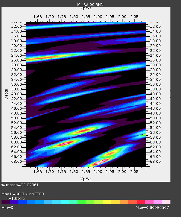
| Estimated Moho Depth: |
68.0 km |
| Estimated Crust Vp/Vs: |
1.91 |
| Assumed Crust Vp: |
6.514 km/s |
| Estimated Crust Vs: |
3.415 km/s |
| Estimated Crust Poisson's Ratio: |
0.31 |
|
| Radial Match: |
93.07361 % |
| Radial Bump: |
400 |
| Transverse Match: |
87.41531 % |
| Transverse Bump: |
400 |
| SOD ConfigId: |
2500 |
| Insert Time: |
2010-03-04 22:46:49.088 +0000 |
| GWidth: |
2.5 |
| Max Bumps: |
400 |
| Tol: |
0.001 |
|
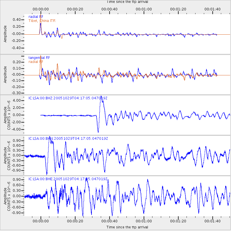
Signal To Noise
| Channel | StoN | STA | LTA |
| IC:LSA:00:BHN:20051029T04:17:05.047019Z | 12.948007 | 4.6146982E-7 | 3.564022E-8 |
| IC:LSA:00:BHE:20051029T04:17:05.047019Z | 5.3581285 | 2.4491754E-7 | 4.570953E-8 |
| IC:LSA:00:BHZ:20051029T04:17:05.047019Z | 33.824917 | 2.009403E-6 | 5.9406002E-8 |
| Arrivals |
| Ps | 9.8 SECOND |
| PpPs | 29 SECOND |
| PsPs/PpSs | 39 SECOND |


