You are here: Home > Network List > CI - Caltech Regional Seismic Network Stations List
> Station VES Vestal, Richgrove, CA, USA > Earthquake Result Viewer
VES Vestal, Richgrove, CA, USA - Earthquake Result Viewer
| Earthquake location: |
Andreanof Islands, Aleutian Is. |
| Earthquake latitude/longitude: |
51.9/-177.5 |
| Earthquake time(UTC): |
2008/05/02 (123) 01:33:37 GMT |
| Earthquake Depth: |
14 km |
| Earthquake Magnitude: |
6.3 MB, 6.8 MS, 6.6 MW, 6.6 MW |
| Earthquake Catalog/Contributor: |
WHDF/NEIC |
|
| Network: |
CI Caltech Regional Seismic Network |
| Station: |
VES Vestal, Richgrove, CA, USA |
| Lat/Lon: |
35.84 N/119.08 W |
| Elevation: |
154 m |
|
| Distance: |
43.9 deg |
| Az: |
87.693 deg |
| Baz: |
310.309 deg |
| Ray Param: |
0.07226573 |
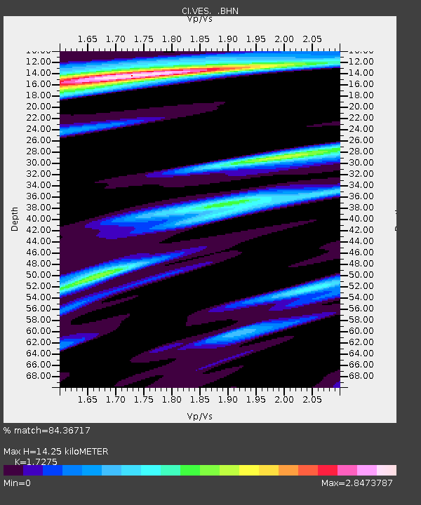
| Estimated Moho Depth: |
14.25 km |
| Estimated Crust Vp/Vs: |
1.73 |
| Assumed Crust Vp: |
6.1 km/s |
| Estimated Crust Vs: |
3.531 km/s |
| Estimated Crust Poisson's Ratio: |
0.25 |
|
| Radial Match: |
84.36717 % |
| Radial Bump: |
351 |
| Transverse Match: |
74.67332 % |
| Transverse Bump: |
392 |
| SOD ConfigId: |
2504 |
| Insert Time: |
2010-02-26 00:01:22.251 +0000 |
| GWidth: |
2.5 |
| Max Bumps: |
400 |
| Tol: |
0.001 |
|

Signal To Noise
| Channel | StoN | STA | LTA |
| CI:VES: :BHN:20080502T01:41:12.082987Z | 11.869391 | 1.961301E-6 | 1.6524024E-7 |
| CI:VES: :BHE:20080502T01:41:12.082987Z | 2.4779391 | 1.8335364E-6 | 7.3994414E-7 |
| CI:VES: :BHZ:20080502T01:41:12.082987Z | 2.9971676 | 1.855793E-6 | 6.191823E-7 |
| Arrivals |
| Ps | 1.8 SECOND |
| PpPs | 6.0 SECOND |
| PsPs/PpSs | 7.8 SECOND |


