You are here: Home > Network List > IC - New China Digital Seismograph Network Stations List
> Station LSA Tibet, China > Earthquake Result Viewer
LSA Tibet, China - Earthquake Result Viewer
| Earthquake location: |
Banda Sea |
| Earthquake latitude/longitude: |
-7.9/125.7 |
| Earthquake time(UTC): |
2008/04/19 (110) 10:21:12 GMT |
| Earthquake Depth: |
10 km |
| Earthquake Magnitude: |
5.6 MB, 5.6 MS, 6.0 MW, 6.0 MW |
| Earthquake Catalog/Contributor: |
WHDF/NEIC |
|
| Network: |
IC New China Digital Seismograph Network |
| Station: |
LSA Tibet, China |
| Lat/Lon: |
29.70 N/91.15 E |
| Elevation: |
3789 m |
|
| Distance: |
50.0 deg |
| Az: |
319.88 deg |
| Baz: |
132.799 deg |
| Ray Param: |
0.06833674 |
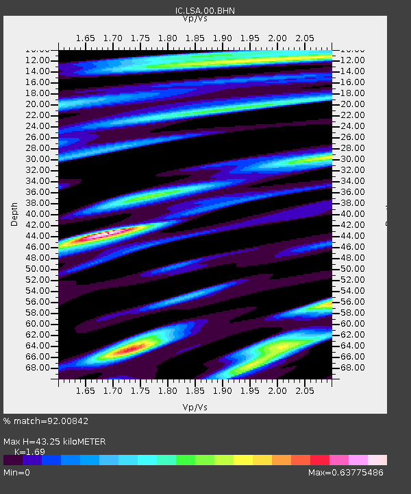
| Estimated Moho Depth: |
43.25 km |
| Estimated Crust Vp/Vs: |
1.69 |
| Assumed Crust Vp: |
6.514 km/s |
| Estimated Crust Vs: |
3.855 km/s |
| Estimated Crust Poisson's Ratio: |
0.23 |
|
| Radial Match: |
92.00842 % |
| Radial Bump: |
400 |
| Transverse Match: |
82.70481 % |
| Transverse Bump: |
400 |
| SOD ConfigId: |
2504 |
| Insert Time: |
2010-03-04 22:47:02.390 +0000 |
| GWidth: |
2.5 |
| Max Bumps: |
400 |
| Tol: |
0.001 |
|
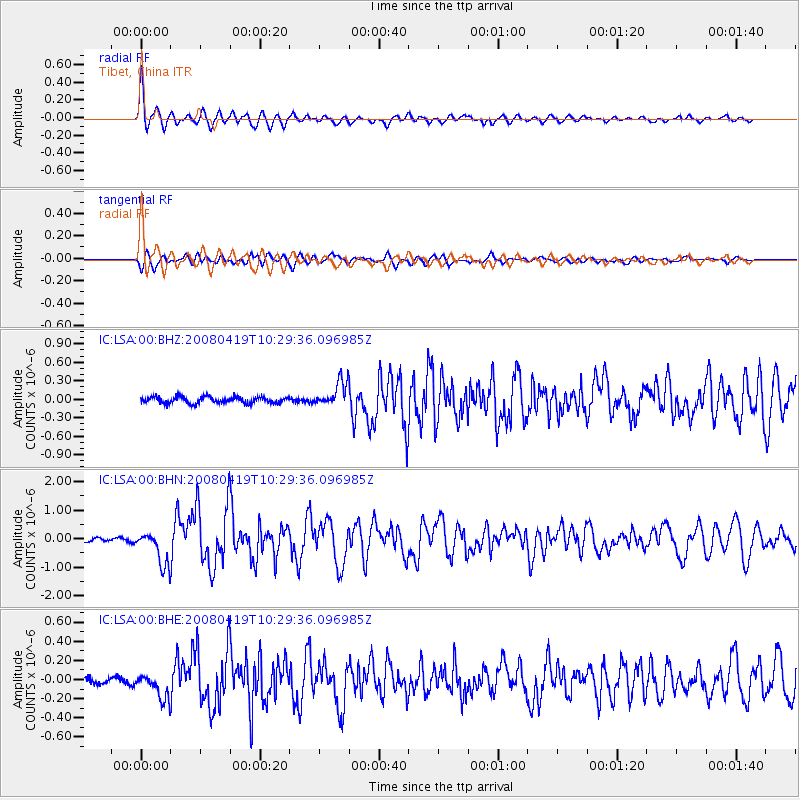
Signal To Noise
| Channel | StoN | STA | LTA |
| IC:LSA:00:BHN:20080419T10:29:36.096985Z | 9.0463 | 5.88892E-7 | 6.509755E-8 |
| IC:LSA:00:BHE:20080419T10:29:36.096985Z | 5.026709 | 1.3160346E-7 | 2.6180839E-8 |
| IC:LSA:00:BHZ:20080419T10:29:36.096985Z | 3.6665409 | 1.8933942E-7 | 5.1639795E-8 |
| Arrivals |
| Ps | 4.9 SECOND |
| PpPs | 17 SECOND |
| PsPs/PpSs | 22 SECOND |


