You are here: Home > Network List > IC - New China Digital Seismograph Network Stations List
> Station LSA Tibet, China > Earthquake Result Viewer
LSA Tibet, China - Earthquake Result Viewer
| Earthquake location: |
Mid-Indian Ridge |
| Earthquake latitude/longitude: |
-41.2/80.5 |
| Earthquake time(UTC): |
2008/05/31 (152) 04:37:56 GMT |
| Earthquake Depth: |
10 km |
| Earthquake Magnitude: |
6.0 MB, 6.3 MS, 6.4 MW, 6.4 MW |
| Earthquake Catalog/Contributor: |
WHDF/NEIC |
|
| Network: |
IC New China Digital Seismograph Network |
| Station: |
LSA Tibet, China |
| Lat/Lon: |
29.70 N/91.15 E |
| Elevation: |
3789 m |
|
| Distance: |
71.2 deg |
| Az: |
9.769 deg |
| Baz: |
188.46 deg |
| Ray Param: |
0.054455448 |
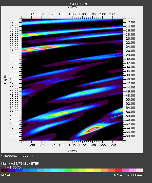
| Estimated Moho Depth: |
24.75 km |
| Estimated Crust Vp/Vs: |
1.66 |
| Assumed Crust Vp: |
6.514 km/s |
| Estimated Crust Vs: |
3.93 km/s |
| Estimated Crust Poisson's Ratio: |
0.21 |
|
| Radial Match: |
93.27733 % |
| Radial Bump: |
400 |
| Transverse Match: |
87.63408 % |
| Transverse Bump: |
400 |
| SOD ConfigId: |
2504 |
| Insert Time: |
2010-03-04 22:47:23.309 +0000 |
| GWidth: |
2.5 |
| Max Bumps: |
400 |
| Tol: |
0.001 |
|
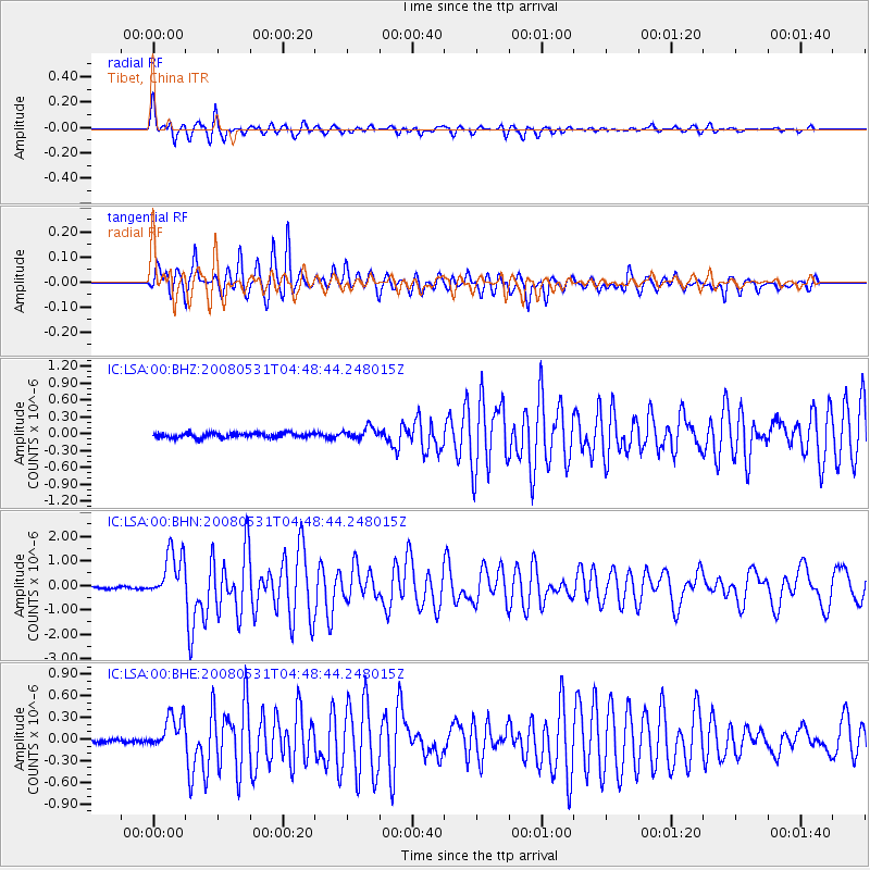
Signal To Noise
| Channel | StoN | STA | LTA |
| IC:LSA:00:BHN:20080531T04:48:44.248015Z | 15.427464 | 1.0035847E-6 | 6.505182E-8 |
| IC:LSA:00:BHE:20080531T04:48:44.248015Z | 8.09609 | 2.4665576E-7 | 3.0466033E-8 |
| IC:LSA:00:BHZ:20080531T04:48:44.248015Z | 2.5604546 | 1.0542435E-7 | 4.1174072E-8 |
| Arrivals |
| Ps | 2.6 SECOND |
| PpPs | 9.7 SECOND |
| PsPs/PpSs | 12 SECOND |


