You are here: Home > Network List > TJ - Tajikistan National Seismic Network Stations List
> Station GARM Garm, Tajikistan > Earthquake Result Viewer
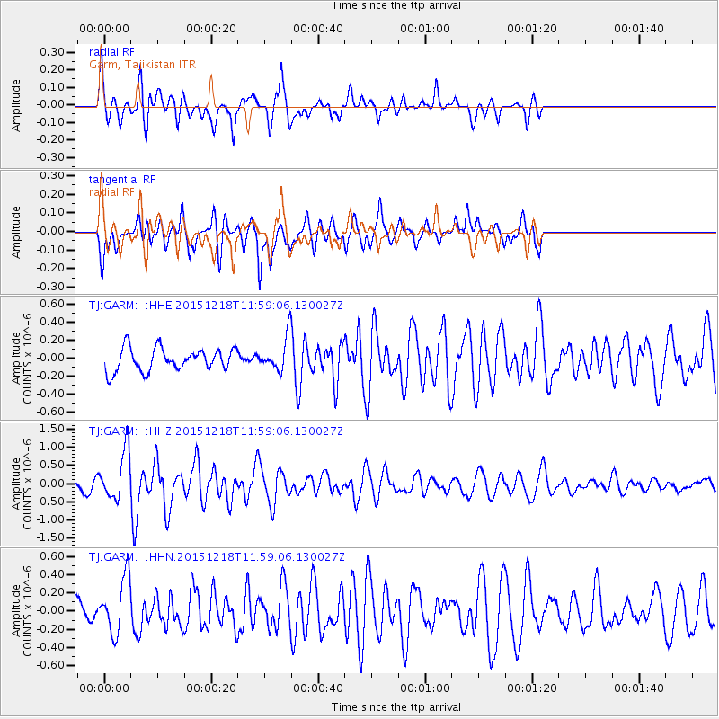
GARM Garm, Tajikistan - Earthquake Result Viewer
*The percent match for this event was below the threshold and hence no stack was calculated.
| Earthquake location: |
North Of Ascension Island |
| Earthquake latitude/longitude: |
-1.4/-15.8 |
| Earthquake time(UTC): |
2015/12/18 (352) 11:46:48 GMT |
| Earthquake Depth: |
10 km |
| Earthquake Magnitude: |
5.6 MB |
| Earthquake Catalog/Contributor: |
NEIC PDE/NEIC COMCAT |
|
| Network: |
TJ Tajikistan National Seismic Network |
| Station: |
GARM Garm, Tajikistan |
| Lat/Lon: |
39.00 N/70.32 E |
| Elevation: |
1305 m |
|
| Distance: |
87.8 deg |
| Az: |
51.077 deg |
| Baz: |
266.533 deg |
| Ray Param: |
$rayparam |
*The percent match for this event was below the threshold and hence was not used in the summary stack. |
|
| Radial Match: |
75.64866 % |
| Radial Bump: |
400 |
| Transverse Match: |
65.11995 % |
| Transverse Bump: |
397 |
| SOD ConfigId: |
7422571 |
| Insert Time: |
2019-04-21 14:50:51.473 +0000 |
| GWidth: |
2.5 |
| Max Bumps: |
400 |
| Tol: |
0.001 |
|
Signal To Noise
| Channel | StoN | STA | LTA |
| TJ:GARM: :HHZ:20151218T11:59:06.130027Z | 4.0807657 | 6.628572E-7 | 1.6243452E-7 |
| TJ:GARM: :HHN:20151218T11:59:06.130027Z | 2.3179615 | 3.050072E-7 | 1.3158424E-7 |
| TJ:GARM: :HHE:20151218T11:59:06.130027Z | 1.7510512 | 2.2053615E-7 | 1.2594501E-7 |
| Arrivals |
| Ps | |
| PpPs | |
| PsPs/PpSs | |


