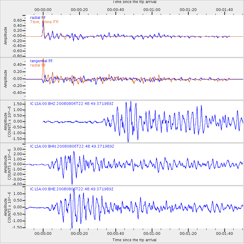
LSA Tibet, China - Earthquake Result Viewer
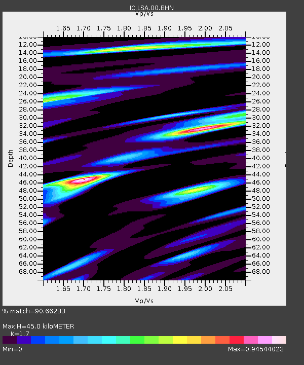
Earthquake location: Sumbawa Region, Indonesia
Earthquake latitude/longitude: -8.1/117.7
Earthquake time(UTC): 2008/08/06 (219) 22:41:03 GMT
Earthquake Depth: 31 km
Earthquake Magnitude: 5.8 MB, 5.5 MS, 5.9 MW, 5.9 MW
Earthquake Catalog/Contributor: WHDF/NEIC
Network: IC New China Digital Seismograph Network
Station: LSA Tibet, China
Lat/Lon: 29.70 N/91.15 E
Elevation: 3789 m
Distance: 45.4 deg
Az: 326.971 deg
Baz: 141.665 deg
Ray Param: 0.07121095
Estimated Moho Depth: 45.0 km
Estimated Crust Vp/Vs: 1.70
Assumed Crust Vp: 6.514 km/s
Estimated Crust Vs: 3.832 km/s
Estimated Crust Poisson's Ratio: 0.24
Radial Match: 90.66283 %
Radial Bump: 400
Transverse Match: 88.432495 %
Transverse Bump: 400
SOD ConfigId: 2504
Insert Time: 2010-03-04 22:47:38.657 +0000
GWidth: 2.5
Max Bumps: 400
Tol: 0.001

Signal To Noise

ChannelStoNSTALTA
IC:LSA:00:BHN:20080806T22:48:49.371989Z5.11443472.999092E-75.8639756E-8
IC:LSA:00:BHE:20080806T22:48:49.371989Z3.15538558.3129045E-82.6345132E-8
IC:LSA:00:BHZ:20080806T22:48:49.371989Z3.06728391.1313157E-73.6883304E-8
Arrivals
Ps5.2 SECOND
PpPs17 SECOND
PsPs/PpSs23 SECOND