You are here: Home > Network List > UW - Pacific Northwest Regional Seismic Network Stations List
> Station YACT Amboy, WA, USA > Earthquake Result Viewer
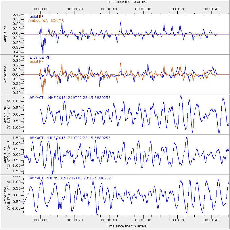
YACT Amboy, WA, USA - Earthquake Result Viewer
*The percent match for this event was below the threshold and hence no stack was calculated.
| Earthquake location: |
Vanuatu Islands |
| Earthquake latitude/longitude: |
-18.4/169.4 |
| Earthquake time(UTC): |
2015/12/19 (353) 02:10:53 GMT |
| Earthquake Depth: |
10 km |
| Earthquake Magnitude: |
6.2 MWP |
| Earthquake Catalog/Contributor: |
NEIC PDE/NEIC COMCAT |
|
| Network: |
UW Pacific Northwest Regional Seismic Network |
| Station: |
YACT Amboy, WA, USA |
| Lat/Lon: |
45.93 N/122.42 W |
| Elevation: |
211 m |
|
| Distance: |
88.8 deg |
| Az: |
40.396 deg |
| Baz: |
241.848 deg |
| Ray Param: |
$rayparam |
*The percent match for this event was below the threshold and hence was not used in the summary stack. |
|
| Radial Match: |
63.498497 % |
| Radial Bump: |
398 |
| Transverse Match: |
41.18476 % |
| Transverse Bump: |
312 |
| SOD ConfigId: |
7422571 |
| Insert Time: |
2019-04-21 14:56:59.386 +0000 |
| GWidth: |
2.5 |
| Max Bumps: |
400 |
| Tol: |
0.001 |
|
Signal To Noise
| Channel | StoN | STA | LTA |
| UW:YACT: :HHZ:20151219T02:23:15.588025Z | 2.0467217 | 9.0417666E-7 | 4.4176826E-7 |
| UW:YACT: :HHN:20151219T02:23:15.588025Z | 1.6683024 | 7.1788196E-7 | 4.3030687E-7 |
| UW:YACT: :HHE:20151219T02:23:15.588025Z | 0.75204015 | 3.1353906E-7 | 4.1691797E-7 |
| Arrivals |
| Ps | |
| PpPs | |
| PsPs/PpSs | |


