You are here: Home > Network List > CI - Caltech Regional Seismic Network Stations List
> Station VES Vestal, Richgrove, CA, USA > Earthquake Result Viewer
VES Vestal, Richgrove, CA, USA - Earthquake Result Viewer
| Earthquake location: |
East Of Kuril Islands |
| Earthquake latitude/longitude: |
46.9/155.2 |
| Earthquake time(UTC): |
2009/01/15 (015) 17:49:39 GMT |
| Earthquake Depth: |
36 km |
| Earthquake Magnitude: |
6.9 MB, 7.5 MS, 7.4 MW, 7.4 MW |
| Earthquake Catalog/Contributor: |
WHDF/NEIC |
|
| Network: |
CI Caltech Regional Seismic Network |
| Station: |
VES Vestal, Richgrove, CA, USA |
| Lat/Lon: |
35.84 N/119.08 W |
| Elevation: |
154 m |
|
| Distance: |
62.3 deg |
| Az: |
66.259 deg |
| Baz: |
309.362 deg |
| Ray Param: |
0.060269885 |
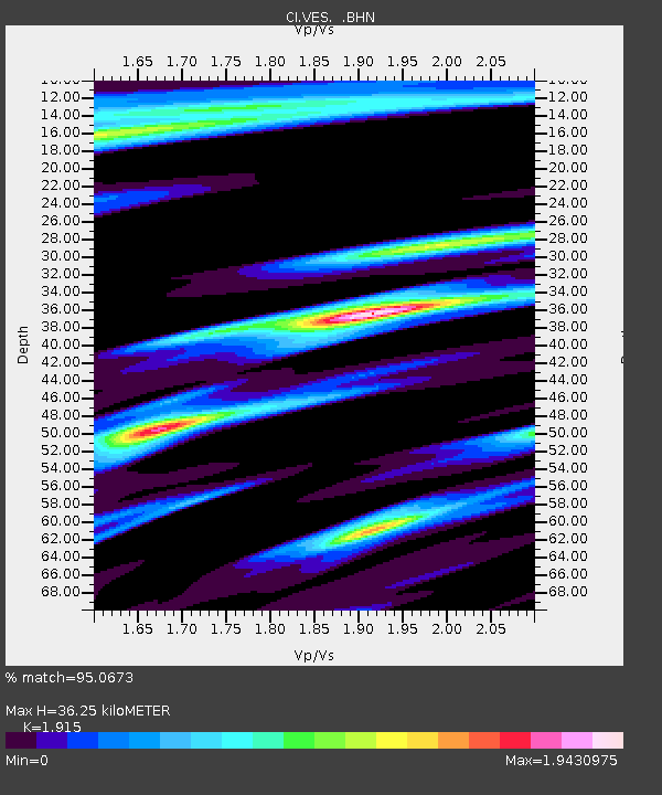
| Estimated Moho Depth: |
36.25 km |
| Estimated Crust Vp/Vs: |
1.91 |
| Assumed Crust Vp: |
6.1 km/s |
| Estimated Crust Vs: |
3.185 km/s |
| Estimated Crust Poisson's Ratio: |
0.31 |
|
| Radial Match: |
95.0673 % |
| Radial Bump: |
399 |
| Transverse Match: |
93.54806 % |
| Transverse Bump: |
376 |
| SOD ConfigId: |
2834 |
| Insert Time: |
2010-02-26 00:01:34.778 +0000 |
| GWidth: |
2.5 |
| Max Bumps: |
400 |
| Tol: |
0.001 |
|

Signal To Noise
| Channel | StoN | STA | LTA |
| CI:VES: :BHN:20090115T17:59:26.70501Z | 67.074104 | 1.0504721E-5 | 1.5661365E-7 |
| CI:VES: :BHE:20090115T17:59:26.70501Z | 11.340617 | 4.0829377E-6 | 3.6002783E-7 |
| CI:VES: :BHZ:20090115T17:59:26.70501Z | 21.605206 | 5.7198017E-6 | 2.6474183E-7 |
| Arrivals |
| Ps | 5.6 SECOND |
| PpPs | 17 SECOND |
| PsPs/PpSs | 22 SECOND |


