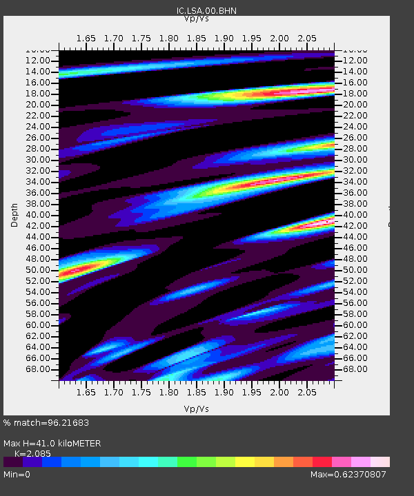
LSA Tibet, China - Earthquake Result Viewer
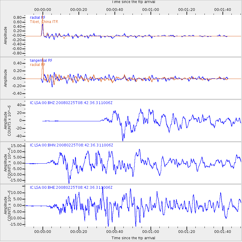
Earthquake location: Southern Sumatra, Indonesia
Earthquake latitude/longitude: -2.5/100.0
Earthquake time(UTC): 2008/02/25 (056) 08:36:33 GMT
Earthquake Depth: 25 km
Earthquake Magnitude: 6.4 MB, 7.3 MS, 7.0 MW, 6.9 MW
Earthquake Catalog/Contributor: WHDF/NEIC
Network: IC New China Digital Seismograph Network
Station: LSA Tibet, China
Lat/Lon: 29.70 N/91.15 E
Elevation: 3789 m
Distance: 33.1 deg
Az: 345.857 deg
Baz: 163.705 deg
Ray Param: 0.07833001
Estimated Moho Depth: 41.0 km
Estimated Crust Vp/Vs: 2.09
Assumed Crust Vp: 6.514 km/s
Estimated Crust Vs: 3.124 km/s
Estimated Crust Poisson's Ratio: 0.35
Radial Match: 96.21683 %
Radial Bump: 400
Transverse Match: 87.09043 %
Transverse Bump: 400
SOD ConfigId: 2564
Insert Time: 2010-03-04 22:48:26.965 +0000
GWidth: 2.5
Max Bumps: 400
Tol: 0.001

Signal To Noise

ChannelStoNSTALTA
IC:LSA:00:BHN:20080225T08:42:36.311006Z16.4131057.886089E-74.804751E-8
IC:LSA:00:BHE:20080225T08:42:36.311006Z6.82715854.380686E-76.416558E-8
IC:LSA:00:BHZ:20080225T08:42:36.311006Z19.2333262.3437963E-61.2186122E-7
Arrivals
Ps7.3 SECOND
PpPs18 SECOND
PsPs/PpSs25 SECOND