You are here: Home > Network List > CI - Caltech Regional Seismic Network Stations List
> Station VES Vestal, Porterville, CA, USA > Earthquake Result Viewer
VES Vestal, Porterville, CA, USA - Earthquake Result Viewer
| Earthquake location: |
Mariana Islands |
| Earthquake latitude/longitude: |
16.0/145.9 |
| Earthquake time(UTC): |
2005/02/05 (036) 03:34:25 GMT |
| Earthquake Depth: |
143 km |
| Earthquake Magnitude: |
6.3 MB, 6.6 MW, 6.5 MW |
| Earthquake Catalog/Contributor: |
WHDF/NEIC |
|
| Network: |
CI Caltech Regional Seismic Network |
| Station: |
VES Vestal, Porterville, CA, USA |
| Lat/Lon: |
35.84 N/119.08 W |
| Elevation: |
154 m |
|
| Distance: |
84.8 deg |
| Az: |
54.364 deg |
| Baz: |
285.854 deg |
| Ray Param: |
0.04491376 |
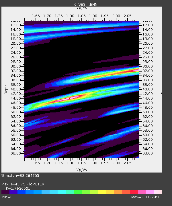
| Estimated Moho Depth: |
43.75 km |
| Estimated Crust Vp/Vs: |
1.80 |
| Assumed Crust Vp: |
6.1 km/s |
| Estimated Crust Vs: |
3.398 km/s |
| Estimated Crust Poisson's Ratio: |
0.27 |
|
| Radial Match: |
83.264755 % |
| Radial Bump: |
340 |
| Transverse Match: |
86.4395 % |
| Transverse Bump: |
375 |
| SOD ConfigId: |
5233 |
| Insert Time: |
2010-02-26 00:01:36.744 +0000 |
| GWidth: |
2.5 |
| Max Bumps: |
400 |
| Tol: |
0.001 |
|
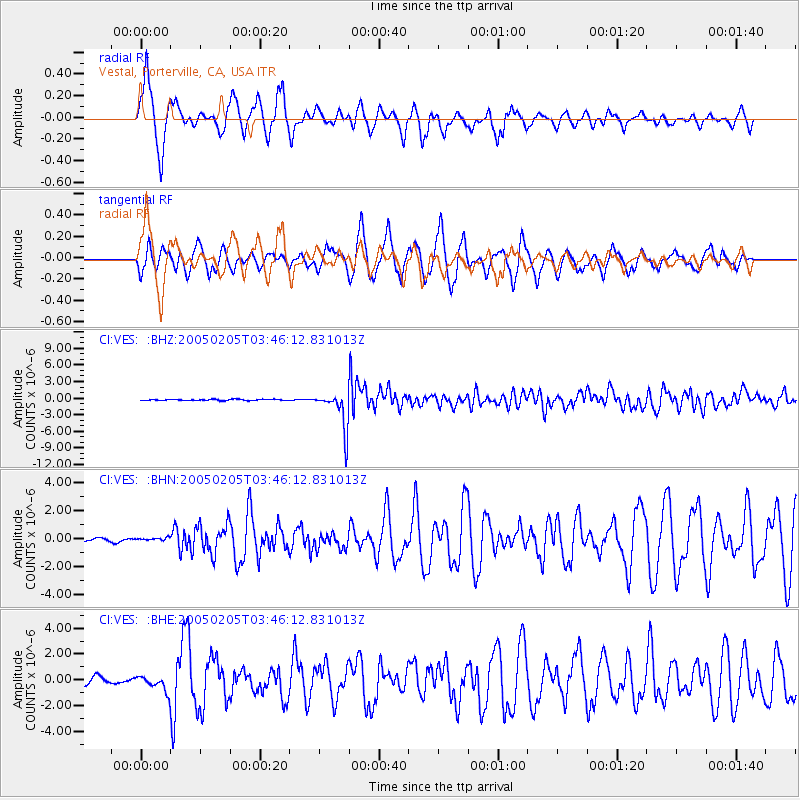
Signal To Noise
| Channel | StoN | STA | LTA |
| CI:VES: :BHN:20050205T03:46:12.831013Z | 0.8520835 | 1.5836267E-7 | 1.8585345E-7 |
| CI:VES: :BHE:20050205T03:46:12.831013Z | 1.5820155 | 5.771E-7 | 3.6478784E-7 |
| CI:VES: :BHZ:20050205T03:46:12.831013Z | 31.804695 | 3.3885651E-6 | 1.0654292E-7 |
| Arrivals |
| Ps | 5.8 SECOND |
| PpPs | 20 SECOND |
| PsPs/PpSs | 25 SECOND |


