You are here: Home > Network List > IC - New China Digital Seismograph Network Stations List
> Station LSA Tibet, China > Earthquake Result Viewer
LSA Tibet, China - Earthquake Result Viewer
| Earthquake location: |
Southern Greece |
| Earthquake latitude/longitude: |
37.2/22.7 |
| Earthquake time(UTC): |
2008/01/06 (006) 05:14:20 GMT |
| Earthquake Depth: |
75 km |
| Earthquake Magnitude: |
6.1 MB, 6.2 MW, 6.1 MW |
| Earthquake Catalog/Contributor: |
WHDF/NEIC |
|
| Network: |
IC New China Digital Seismograph Network |
| Station: |
LSA Tibet, China |
| Lat/Lon: |
29.70 N/91.15 E |
| Elevation: |
3789 m |
|
| Distance: |
56.5 deg |
| Az: |
76.044 deg |
| Baz: |
297.07 deg |
| Ray Param: |
0.063892335 |
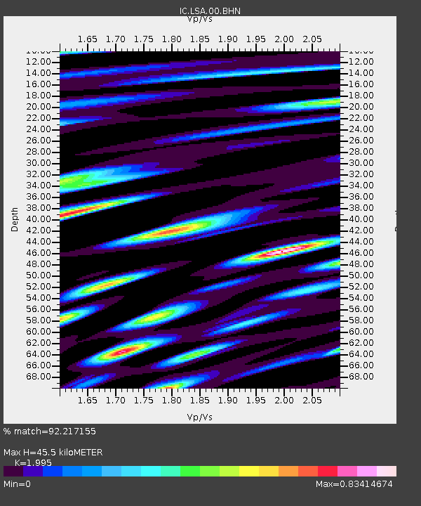
| Estimated Moho Depth: |
45.5 km |
| Estimated Crust Vp/Vs: |
2.00 |
| Assumed Crust Vp: |
6.514 km/s |
| Estimated Crust Vs: |
3.265 km/s |
| Estimated Crust Poisson's Ratio: |
0.33 |
|
| Radial Match: |
92.217155 % |
| Radial Bump: |
400 |
| Transverse Match: |
89.0438 % |
| Transverse Bump: |
400 |
| SOD ConfigId: |
2564 |
| Insert Time: |
2010-03-04 22:48:45.223 +0000 |
| GWidth: |
2.5 |
| Max Bumps: |
400 |
| Tol: |
0.001 |
|
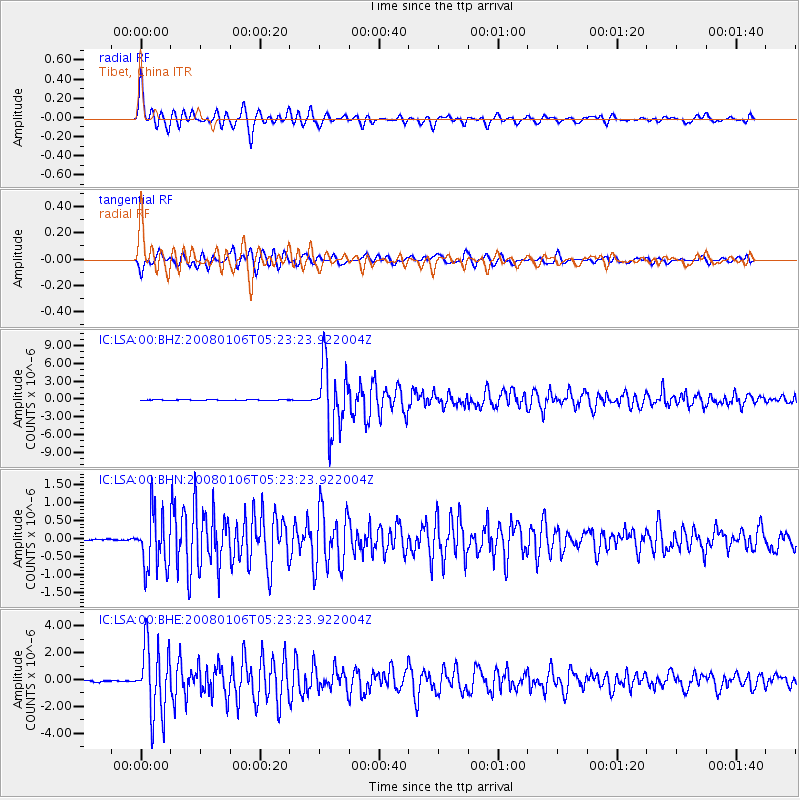
Signal To Noise
| Channel | StoN | STA | LTA |
| IC:LSA:00:BHN:20080106T05:23:23.922004Z | 37.03323 | 7.707834E-7 | 2.0813292E-8 |
| IC:LSA:00:BHE:20080106T05:23:23.922004Z | 66.67657 | 2.5909037E-6 | 3.8857785E-8 |
| IC:LSA:00:BHZ:20080106T05:23:23.922004Z | 95.018036 | 5.3413182E-6 | 5.6213732E-8 |
| Arrivals |
| Ps | 7.3 SECOND |
| PpPs | 20 SECOND |
| PsPs/PpSs | 27 SECOND |


