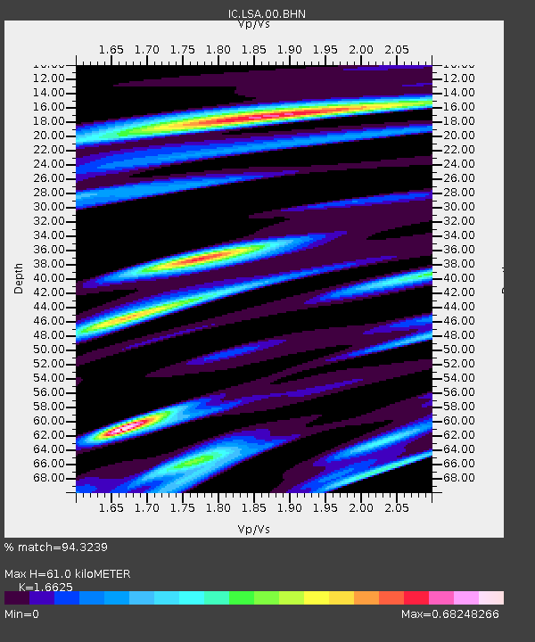
LSA Tibet, China - Earthquake Result Viewer
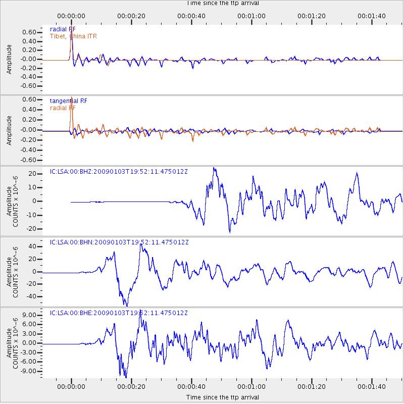
Earthquake location: Irian Jaya Region, Indonesia
Earthquake latitude/longitude: -0.4/132.9
Earthquake time(UTC): 2009/01/03 (003) 19:43:50 GMT
Earthquake Depth: 17 km
Earthquake Magnitude: 6.6 MB, 7.5 MS, 7.6 MW, 7.6 MW
Earthquake Catalog/Contributor: WHDF/NEIC
Network: IC New China Digital Seismograph Network
Station: LSA Tibet, China
Lat/Lon: 29.70 N/91.15 E
Elevation: 3789 m
Distance: 49.8 deg
Az: 310.667 deg
Baz: 119.335 deg
Ray Param: 0.06846489
Estimated Moho Depth: 61.0 km
Estimated Crust Vp/Vs: 1.66
Assumed Crust Vp: 6.514 km/s
Estimated Crust Vs: 3.918 km/s
Estimated Crust Poisson's Ratio: 0.22
Radial Match: 94.3239 %
Radial Bump: 400
Transverse Match: 90.29156 %
Transverse Bump: 400
SOD ConfigId: 2834
Insert Time: 2010-03-04 22:48:49.459 +0000
GWidth: 2.5
Max Bumps: 400
Tol: 0.001

Signal To Noise

ChannelStoNSTALTA
IC:LSA:00:BHN:20090103T19:52:11.475012Z2.97593885.739555E-71.9286537E-7
IC:LSA:00:BHE:20090103T19:52:11.475012Z3.2899781.0916855E-73.3182154E-8
IC:LSA:00:BHZ:20090103T19:52:11.475012Z2.68233062.8218273E-71.0520058E-7
Arrivals
Ps6.6 SECOND
PpPs23 SECOND
PsPs/PpSs30 SECOND