You are here: Home > Network List > CI - Caltech Regional Seismic Network Stations List
> Station VES Vestal, Porterville, CA, USA > Earthquake Result Viewer
VES Vestal, Porterville, CA, USA - Earthquake Result Viewer
| Earthquake location: |
Off East Coast Of Honshu, Japan |
| Earthquake latitude/longitude: |
38.1/144.9 |
| Earthquake time(UTC): |
2005/11/14 (318) 21:38:51 GMT |
| Earthquake Depth: |
11 km |
| Earthquake Magnitude: |
6.7 MB, 6.8 MS, 7.0 MW, 6.9 MW |
| Earthquake Catalog/Contributor: |
WHDF/NEIC |
|
| Network: |
CI Caltech Regional Seismic Network |
| Station: |
VES Vestal, Porterville, CA, USA |
| Lat/Lon: |
35.84 N/119.08 W |
| Elevation: |
154 m |
|
| Distance: |
73.1 deg |
| Az: |
57.628 deg |
| Baz: |
304.913 deg |
| Ray Param: |
0.05323783 |
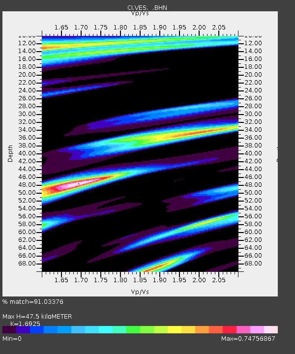
| Estimated Moho Depth: |
47.5 km |
| Estimated Crust Vp/Vs: |
1.69 |
| Assumed Crust Vp: |
6.1 km/s |
| Estimated Crust Vs: |
3.604 km/s |
| Estimated Crust Poisson's Ratio: |
0.23 |
|
| Radial Match: |
91.03376 % |
| Radial Bump: |
400 |
| Transverse Match: |
90.00834 % |
| Transverse Bump: |
341 |
| SOD ConfigId: |
2448 |
| Insert Time: |
2010-02-26 00:01:40.596 +0000 |
| GWidth: |
2.5 |
| Max Bumps: |
400 |
| Tol: |
0.001 |
|
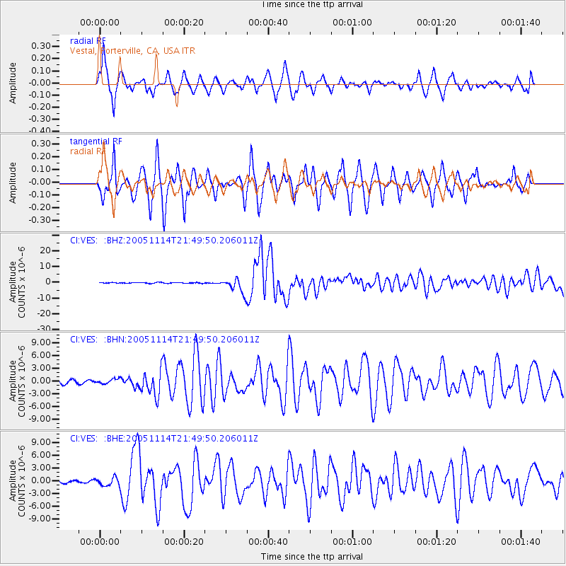
Signal To Noise
| Channel | StoN | STA | LTA |
| CI:VES: :BHN:20051114T21:49:50.206011Z | 0.72640914 | 5.784099E-7 | 7.9625914E-7 |
| CI:VES: :BHE:20051114T21:49:50.206011Z | 1.7177453 | 9.724903E-7 | 5.6614346E-7 |
| CI:VES: :BHZ:20051114T21:49:50.206011Z | 20.986044 | 4.927424E-6 | 2.3479527E-7 |
| Arrivals |
| Ps | 5.6 SECOND |
| PpPs | 20 SECOND |
| PsPs/PpSs | 26 SECOND |


