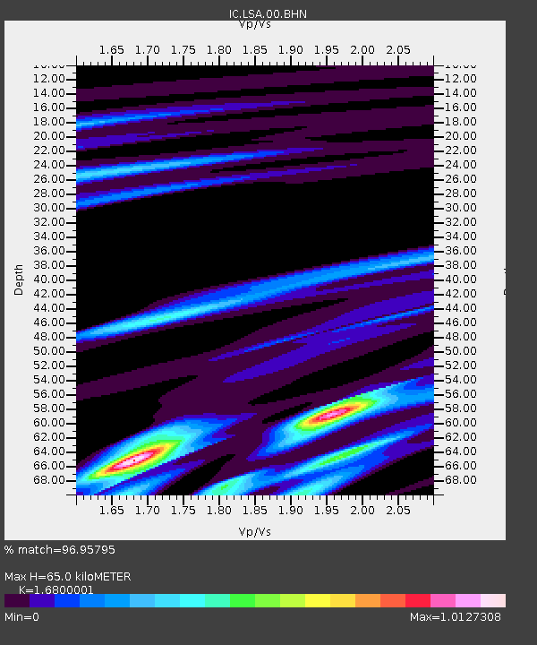
LSA Tibet, China - Earthquake Result Viewer
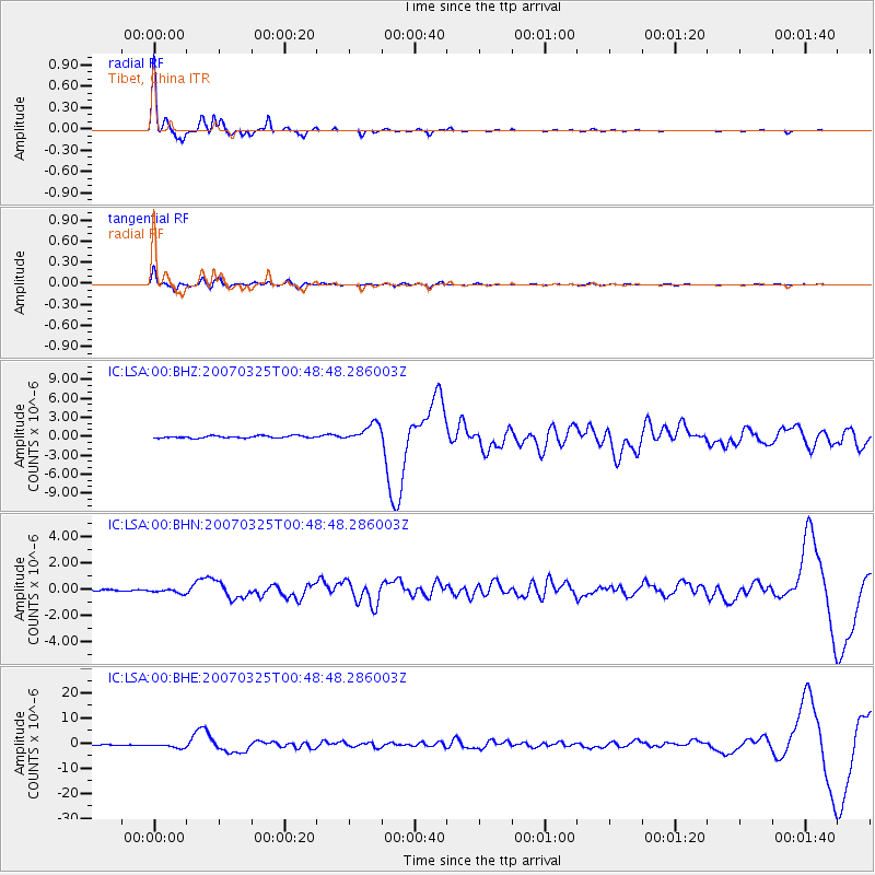
Earthquake location: Near West Coast Of Honshu, Japan
Earthquake latitude/longitude: 37.3/136.6
Earthquake time(UTC): 2007/03/25 (084) 00:41:57 GMT
Earthquake Depth: 8.0 km
Earthquake Magnitude: 6.1 MB, 6.8 MS, 6.7 MW, 6.6 MW
Earthquake Catalog/Contributor: WHDF/NEIC
Network: IC New China Digital Seismograph Network
Station: LSA Tibet, China
Lat/Lon: 29.70 N/91.15 E
Elevation: 3789 m
Distance: 38.3 deg
Az: 272.237 deg
Baz: 66.261 deg
Ray Param: 0.075621255
Estimated Moho Depth: 65.0 km
Estimated Crust Vp/Vs: 1.68
Assumed Crust Vp: 6.514 km/s
Estimated Crust Vs: 3.878 km/s
Estimated Crust Poisson's Ratio: 0.23
Radial Match: 96.95795 %
Radial Bump: 204
Transverse Match: 93.58495 %
Transverse Bump: 400
SOD ConfigId: 2564
Insert Time: 2010-03-04 22:49:28.885 +0000
GWidth: 2.5
Max Bumps: 400
Tol: 0.001

Signal To Noise

ChannelStoNSTALTA
IC:LSA:00:BHN:20070325T00:48:48.286003Z3.2016521.8994294E-75.932654E-8
IC:LSA:00:BHE:20070325T00:48:48.286003Z7.09701738.814837E-71.2420482E-7
IC:LSA:00:BHZ:20070325T00:48:48.286003Z8.3468591.4247289E-61.7069041E-7
Arrivals
Ps7.3 SECOND
PpPs25 SECOND
PsPs/PpSs32 SECOND