You are here: Home > Network List > IC - New China Digital Seismograph Network Stations List
> Station LSA Tibet, China > Earthquake Result Viewer
LSA Tibet, China - Earthquake Result Viewer
| Earthquake location: |
Mid-Indian Ridge |
| Earthquake latitude/longitude: |
-11.4/66.3 |
| Earthquake time(UTC): |
2007/03/09 (068) 07:27:31 GMT |
| Earthquake Depth: |
10 km |
| Earthquake Magnitude: |
5.8 MB, 5.6 MS, 5.7 MW, 5.5 MW |
| Earthquake Catalog/Contributor: |
WHDF/NEIC |
|
| Network: |
IC New China Digital Seismograph Network |
| Station: |
LSA Tibet, China |
| Lat/Lon: |
29.70 N/91.15 E |
| Elevation: |
3789 m |
|
| Distance: |
47.4 deg |
| Az: |
29.833 deg |
| Baz: |
214.096 deg |
| Ray Param: |
0.070007324 |
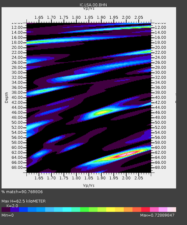
| Estimated Moho Depth: |
62.5 km |
| Estimated Crust Vp/Vs: |
2.00 |
| Assumed Crust Vp: |
6.514 km/s |
| Estimated Crust Vs: |
3.257 km/s |
| Estimated Crust Poisson's Ratio: |
0.33 |
|
| Radial Match: |
90.769806 % |
| Radial Bump: |
400 |
| Transverse Match: |
82.78293 % |
| Transverse Bump: |
400 |
| SOD ConfigId: |
2564 |
| Insert Time: |
2010-03-04 22:49:33.368 +0000 |
| GWidth: |
2.5 |
| Max Bumps: |
400 |
| Tol: |
0.001 |
|
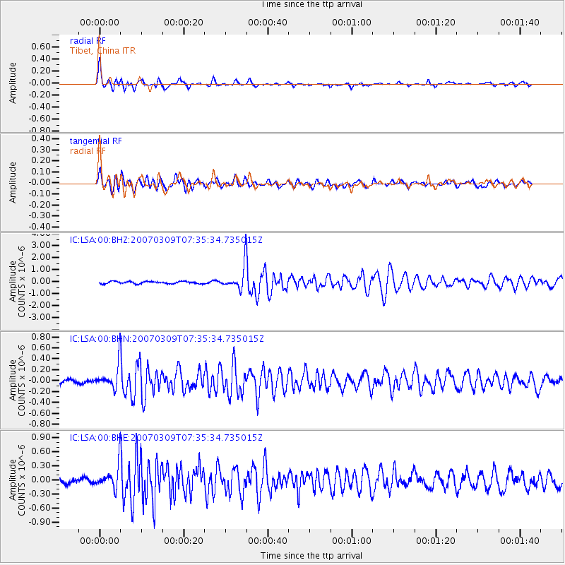
Signal To Noise
| Channel | StoN | STA | LTA |
| IC:LSA:00:BHN:20070309T07:35:34.735015Z | 5.4189405 | 2.267013E-7 | 4.1834987E-8 |
| IC:LSA:00:BHE:20070309T07:35:34.735015Z | 3.9938731 | 2.5586928E-7 | 6.4065446E-8 |
| IC:LSA:00:BHZ:20070309T07:35:34.735015Z | 11.437438 | 1.0206344E-6 | 8.923627E-8 |
| Arrivals |
| Ps | 10 SECOND |
| PpPs | 27 SECOND |
| PsPs/PpSs | 37 SECOND |


