You are here: Home > Network List > TA - USArray Transportable Network (new EarthScope stations) Stations List
> Station L44A Lake County Forest Preserve, Grayslake, IL, USA > Earthquake Result Viewer
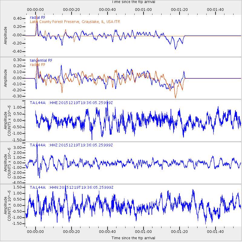
L44A Lake County Forest Preserve, Grayslake, IL, USA - Earthquake Result Viewer
*The percent match for this event was below the threshold and hence no stack was calculated.
| Earthquake location: |
Near Coast Of Central Chile |
| Earthquake latitude/longitude: |
-30.6/-71.4 |
| Earthquake time(UTC): |
2015/12/19 (353) 19:25:04 GMT |
| Earthquake Depth: |
46 km |
| Earthquake Magnitude: |
5.8 MWR |
| Earthquake Catalog/Contributor: |
NEIC PDE/NEIC COMCAT |
|
| Network: |
TA USArray Transportable Network (new EarthScope stations) |
| Station: |
L44A Lake County Forest Preserve, Grayslake, IL, USA |
| Lat/Lon: |
42.18 N/87.91 W |
| Elevation: |
202 m |
|
| Distance: |
74.1 deg |
| Az: |
347.283 deg |
| Baz: |
165.213 deg |
| Ray Param: |
$rayparam |
*The percent match for this event was below the threshold and hence was not used in the summary stack. |
|
| Radial Match: |
46.467964 % |
| Radial Bump: |
400 |
| Transverse Match: |
50.043365 % |
| Transverse Bump: |
400 |
| SOD ConfigId: |
7422571 |
| Insert Time: |
2019-04-21 15:09:13.102 +0000 |
| GWidth: |
2.5 |
| Max Bumps: |
400 |
| Tol: |
0.001 |
|
Signal To Noise
| Channel | StoN | STA | LTA |
| TA:L44A: :HHZ:20151219T19:36:05.25999Z | 2.750293 | 1.3848722E-6 | 5.035363E-7 |
| TA:L44A: :HHN:20151219T19:36:05.25999Z | 1.3876473 | 6.397797E-7 | 4.610536E-7 |
| TA:L44A: :HHE:20151219T19:36:05.25999Z | 2.0664062 | 5.674803E-7 | 2.7462184E-7 |
| Arrivals |
| Ps | |
| PpPs | |
| PsPs/PpSs | |


