You are here: Home > Network List > TA - USArray Transportable Network (new EarthScope stations) Stations List
> Station MSTX Muleshoe, TX, USA > Earthquake Result Viewer
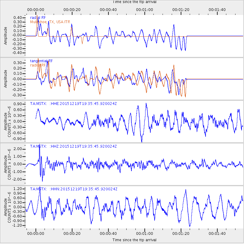
MSTX Muleshoe, TX, USA - Earthquake Result Viewer
*The percent match for this event was below the threshold and hence no stack was calculated.
| Earthquake location: |
Near Coast Of Central Chile |
| Earthquake latitude/longitude: |
-30.6/-71.4 |
| Earthquake time(UTC): |
2015/12/19 (353) 19:25:04 GMT |
| Earthquake Depth: |
46 km |
| Earthquake Magnitude: |
5.8 MWR |
| Earthquake Catalog/Contributor: |
NEIC PDE/NEIC COMCAT |
|
| Network: |
TA USArray Transportable Network (new EarthScope stations) |
| Station: |
MSTX Muleshoe, TX, USA |
| Lat/Lon: |
33.97 N/102.77 W |
| Elevation: |
1167 m |
|
| Distance: |
70.8 deg |
| Az: |
332.702 deg |
| Baz: |
151.602 deg |
| Ray Param: |
$rayparam |
*The percent match for this event was below the threshold and hence was not used in the summary stack. |
|
| Radial Match: |
47.894386 % |
| Radial Bump: |
400 |
| Transverse Match: |
68.37101 % |
| Transverse Bump: |
400 |
| SOD ConfigId: |
7422571 |
| Insert Time: |
2019-04-21 15:09:15.651 +0000 |
| GWidth: |
2.5 |
| Max Bumps: |
400 |
| Tol: |
0.001 |
|
Signal To Noise
| Channel | StoN | STA | LTA |
| TA:MSTX: :HHZ:20151219T19:35:45.920024Z | 4.2318997 | 1.0163443E-6 | 2.4016265E-7 |
| TA:MSTX: :HHN:20151219T19:35:45.920024Z | 1.1667411 | 5.7415053E-7 | 4.920976E-7 |
| TA:MSTX: :HHE:20151219T19:35:45.920024Z | 1.2373323 | 2.4347128E-7 | 1.9677114E-7 |
| Arrivals |
| Ps | |
| PpPs | |
| PsPs/PpSs | |


