You are here: Home > Network List > TA - USArray Transportable Network (new EarthScope stations) Stations List
> Station Z41A Richland Creek Farm, El Dorado, AR, USA > Earthquake Result Viewer
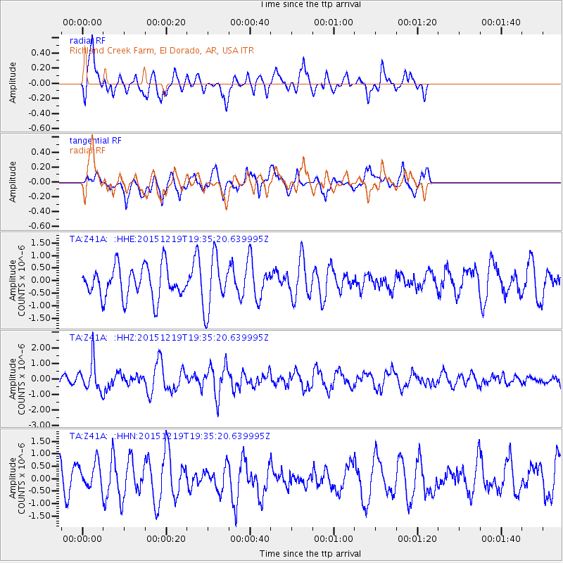
Z41A Richland Creek Farm, El Dorado, AR, USA - Earthquake Result Viewer
*The percent match for this event was below the threshold and hence no stack was calculated.
| Earthquake location: |
Near Coast Of Central Chile |
| Earthquake latitude/longitude: |
-30.6/-71.4 |
| Earthquake time(UTC): |
2015/12/19 (353) 19:25:04 GMT |
| Earthquake Depth: |
46 km |
| Earthquake Magnitude: |
5.8 MWR |
| Earthquake Catalog/Contributor: |
NEIC PDE/NEIC COMCAT |
|
| Network: |
TA USArray Transportable Network (new EarthScope stations) |
| Station: |
Z41A Richland Creek Farm, El Dorado, AR, USA |
| Lat/Lon: |
33.26 N/92.80 W |
| Elevation: |
62 m |
|
| Distance: |
66.7 deg |
| Az: |
340.527 deg |
| Baz: |
159.947 deg |
| Ray Param: |
$rayparam |
*The percent match for this event was below the threshold and hence was not used in the summary stack. |
|
| Radial Match: |
49.69562 % |
| Radial Bump: |
376 |
| Transverse Match: |
60.779552 % |
| Transverse Bump: |
400 |
| SOD ConfigId: |
7422571 |
| Insert Time: |
2019-04-21 15:09:36.333 +0000 |
| GWidth: |
2.5 |
| Max Bumps: |
400 |
| Tol: |
0.001 |
|
Signal To Noise
| Channel | StoN | STA | LTA |
| TA:Z41A: :HHZ:20151219T19:35:20.639995Z | 2.9252937 | 9.745642E-7 | 3.331509E-7 |
| TA:Z41A: :HHN:20151219T19:35:20.639995Z | 0.5016093 | 5.5246363E-7 | 1.1013823E-6 |
| TA:Z41A: :HHE:20151219T19:35:20.639995Z | 1.7223009 | 1.0844242E-6 | 6.2963693E-7 |
| Arrivals |
| Ps | |
| PpPs | |
| PsPs/PpSs | |


