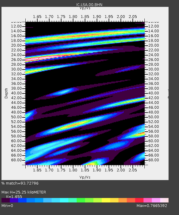
LSA Tibet, China - Earthquake Result Viewer
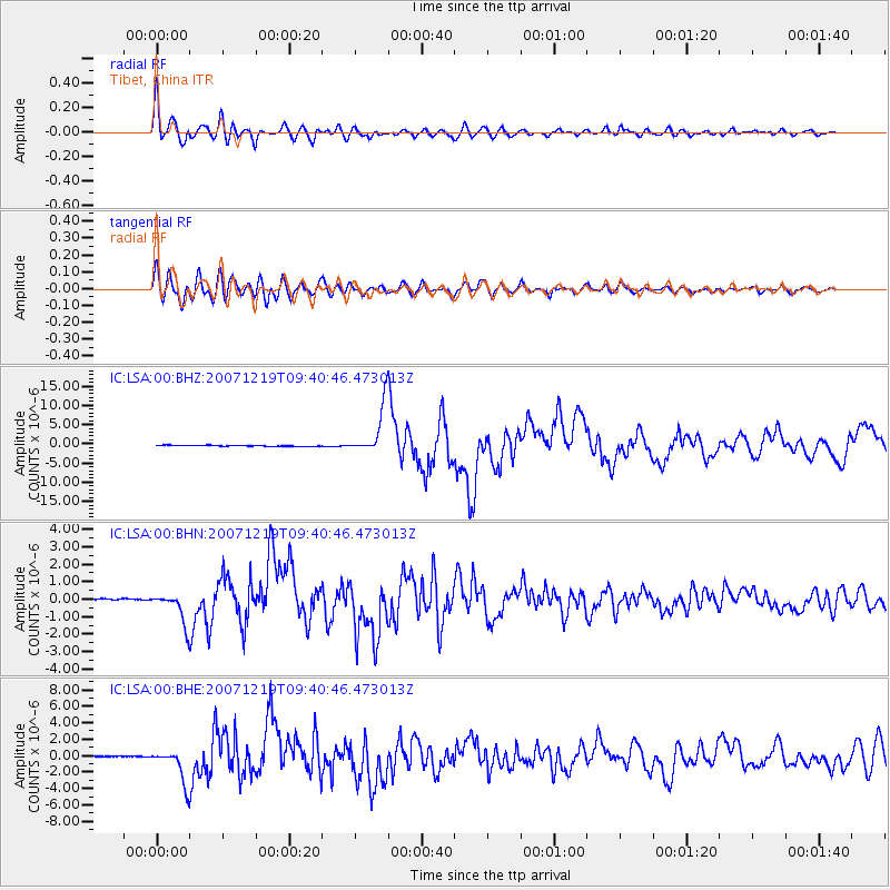
Earthquake location: Andreanof Islands, Aleutian Is.
Earthquake latitude/longitude: 51.4/-179.5
Earthquake time(UTC): 2007/12/19 (353) 09:30:27 GMT
Earthquake Depth: 29 km
Earthquake Magnitude: 6.4 MB, 7.1 MS, 7.1 MW, 7.0 MW
Earthquake Catalog/Contributor: WHDF/NEIC
Network: IC New China Digital Seismograph Network
Station: LSA Tibet, China
Lat/Lon: 29.70 N/91.15 E
Elevation: 3789 m
Distance: 67.0 deg
Az: 289.09 deg
Baz: 42.918 deg
Ray Param: 0.057187084
Estimated Moho Depth: 25.25 km
Estimated Crust Vp/Vs: 1.65
Assumed Crust Vp: 6.514 km/s
Estimated Crust Vs: 3.936 km/s
Estimated Crust Poisson's Ratio: 0.21
Radial Match: 93.72796 %
Radial Bump: 400
Transverse Match: 87.18046 %
Transverse Bump: 400
SOD ConfigId: 2564
Insert Time: 2010-03-04 22:49:56.880 +0000
GWidth: 2.5
Max Bumps: 400
Tol: 0.001

Signal To Noise

ChannelStoNSTALTA
IC:LSA:00:BHN:20071219T09:40:46.473013Z18.8556778.7749214E-74.653729E-8
IC:LSA:00:BHE:20071219T09:40:46.473013Z31.0637512.038689E-66.5629195E-8
IC:LSA:00:BHZ:20071219T09:40:46.473013Z51.4152576.2792137E-61.2212743E-7
Arrivals
Ps2.7 SECOND
PpPs9.8 SECOND
PsPs/PpSs13 SECOND