You are here: Home > Network List > IC - New China Digital Seismograph Network Stations List
> Station LSA Tibet, China > Earthquake Result Viewer
LSA Tibet, China - Earthquake Result Viewer
| Earthquake location: |
Tanzania |
| Earthquake latitude/longitude: |
-7.6/37.6 |
| Earthquake time(UTC): |
2007/12/08 (342) 19:55:20 GMT |
| Earthquake Depth: |
10 km |
| Earthquake Magnitude: |
5.6 MW, 5.2 MS, 5.4 MB |
| Earthquake Catalog/Contributor: |
WHDF/NEIC |
|
| Network: |
IC New China Digital Seismograph Network |
| Station: |
LSA Tibet, China |
| Lat/Lon: |
29.70 N/91.15 E |
| Elevation: |
3789 m |
|
| Distance: |
63.3 deg |
| Az: |
51.5 deg |
| Baz: |
243.098 deg |
| Ray Param: |
0.05963982 |
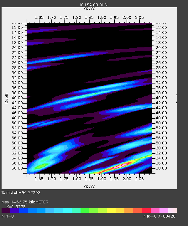
| Estimated Moho Depth: |
66.75 km |
| Estimated Crust Vp/Vs: |
1.98 |
| Assumed Crust Vp: |
6.514 km/s |
| Estimated Crust Vs: |
3.294 km/s |
| Estimated Crust Poisson's Ratio: |
0.33 |
|
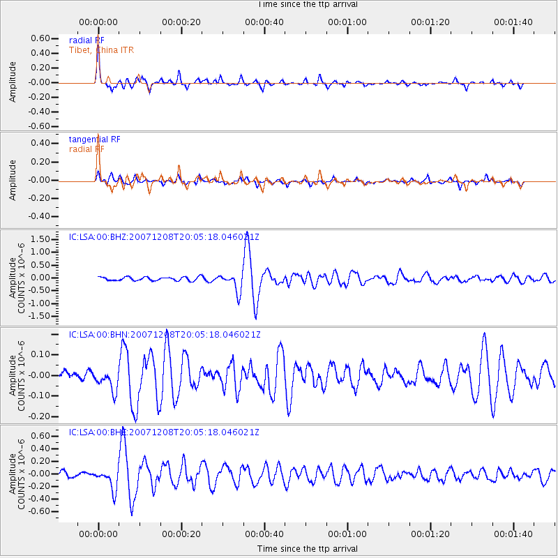
| Radial Match: |
90.72293 % |
| Radial Bump: |
385 |
| Transverse Match: |
83.91688 % |
| Transverse Bump: |
400 |
| SOD ConfigId: |
2564 |
| Insert Time: |
2010-03-04 22:49:58.271 +0000 |
| GWidth: |
2.5 |
| Max Bumps: |
400 |
| Tol: |
0.001 |
|
Signal To Noise
| Channel | StoN | STA | LTA |
| IC:LSA:00:BHN:20071208T20:05:18.046021Z | 1.5226805 | 4.9907793E-8 | 3.2776274E-8 |
| IC:LSA:00:BHE:20071208T20:05:18.046021Z | 4.6657214 | 1.6843978E-7 | 3.610155E-8 |
| IC:LSA:00:BHZ:20071208T20:05:18.046021Z | 5.3145356 | 3.746297E-7 | 7.0491524E-8 |
| Arrivals |
| Ps | 10 SECOND |
| PpPs | 29 SECOND |
| PsPs/PpSs | 40 SECOND |


