You are here: Home > Network List > JP - Japan Meteorological Agency Seismic Network Stations List
> Station JSD Sado > Earthquake Result Viewer
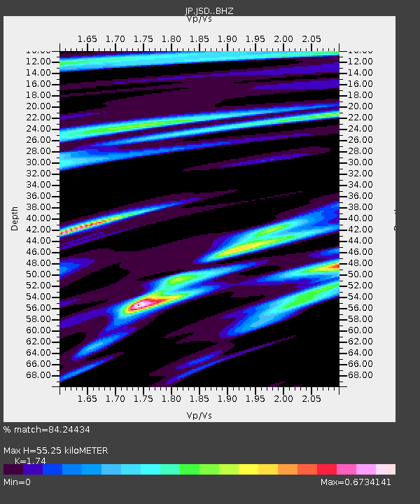
JSD Sado - Earthquake Result Viewer
| Earthquake location: |
Borneo |
| Earthquake latitude/longitude: |
3.6/117.6 |
| Earthquake time(UTC): |
2015/12/20 (354) 18:47:35 GMT |
| Earthquake Depth: |
9.0 km |
| Earthquake Magnitude: |
6.0 MWP |
| Earthquake Catalog/Contributor: |
NEIC PDE/NEIC COMCAT |
|
| Network: |
JP Japan Meteorological Agency Seismic Network |
| Station: |
JSD Sado |
| Lat/Lon: |
38.04 N/138.26 E |
| Elevation: |
146 m |
|
| Distance: |
39.1 deg |
| Az: |
26.18 deg |
| Baz: |
213.894 deg |
| Ray Param: |
0.07518495 |
| Estimated Moho Depth: |
55.25 km |
| Estimated Crust Vp/Vs: |
1.74 |
| Assumed Crust Vp: |
6.183 km/s |
| Estimated Crust Vs: |
3.553 km/s |
| Estimated Crust Poisson's Ratio: |
0.25 |
|
| Radial Match: |
84.24434 % |
| Radial Bump: |
400 |
| Transverse Match: |
57.13698 % |
| Transverse Bump: |
400 |
| SOD ConfigId: |
7422571 |
| Insert Time: |
2019-04-21 15:14:00.337 +0000 |
| GWidth: |
2.5 |
| Max Bumps: |
400 |
| Tol: |
0.001 |
|

Signal To Noise
| Channel | StoN | STA | LTA |
| JP:JSD: :BHZ:20151220T18:54:32.300012Z | 6.118051 | 1.2673588E-6 | 2.0715075E-7 |
| JP:JSD: :BHN:20151220T18:54:32.300012Z | 2.3127239 | 5.8714096E-7 | 2.5387422E-7 |
| JP:JSD: :BHE:20151220T18:54:32.300012Z | 0.88216233 | 4.2737494E-7 | 4.8446293E-7 |
| Arrivals |
| Ps | 7.1 SECOND |
| PpPs | 23 SECOND |
| PsPs/PpSs | 30 SECOND |


