You are here: Home > Network List > ND - New CaleDonia Broadband Seismic Network Stations List
> Station KOUNC Koumac, New Caledonia > Earthquake Result Viewer
KOUNC Koumac, New Caledonia - Earthquake Result Viewer
| Earthquake location: |
Borneo |
| Earthquake latitude/longitude: |
3.6/117.6 |
| Earthquake time(UTC): |
2015/12/20 (354) 18:47:35 GMT |
| Earthquake Depth: |
9.0 km |
| Earthquake Magnitude: |
6.0 MWP |
| Earthquake Catalog/Contributor: |
NEIC PDE/NEIC COMCAT |
|
| Network: |
ND New CaleDonia Broadband Seismic Network |
| Station: |
KOUNC Koumac, New Caledonia |
| Lat/Lon: |
20.55 S/164.29 E |
| Elevation: |
88 m |
|
| Distance: |
51.7 deg |
| Az: |
119.7 deg |
| Baz: |
292.322 deg |
| Ray Param: |
0.06725209 |
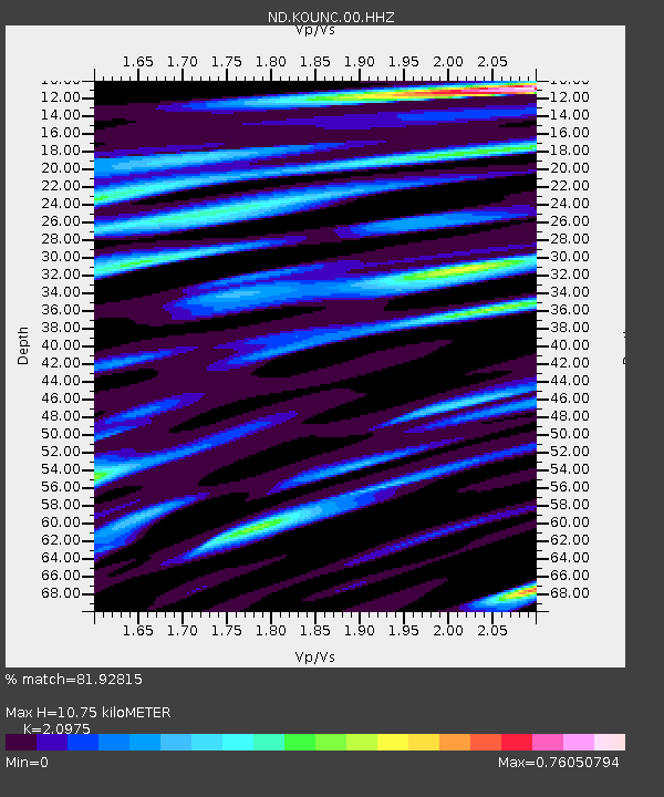
| Estimated Moho Depth: |
10.75 km |
| Estimated Crust Vp/Vs: |
2.10 |
| Assumed Crust Vp: |
5.14 km/s |
| Estimated Crust Vs: |
2.451 km/s |
| Estimated Crust Poisson's Ratio: |
0.35 |
|
| Radial Match: |
81.92815 % |
| Radial Bump: |
351 |
| Transverse Match: |
60.072895 % |
| Transverse Bump: |
400 |
| SOD ConfigId: |
7422571 |
| Insert Time: |
2019-04-21 15:14:29.621 +0000 |
| GWidth: |
2.5 |
| Max Bumps: |
400 |
| Tol: |
0.001 |
|

Signal To Noise
| Channel | StoN | STA | LTA |
| ND:KOUNC:00:HHZ:20151220T18:56:12.03103Z | 8.241289 | 2.5433892E-6 | 3.0861545E-7 |
| ND:KOUNC:00:HHN:20151220T18:56:12.03103Z | 1.8335179 | 6.4710537E-7 | 3.5293104E-7 |
| ND:KOUNC:00:HHE:20151220T18:56:12.03103Z | 4.884021 | 1.2859637E-6 | 2.633002E-7 |
| Arrivals |
| Ps | 2.4 SECOND |
| PpPs | 6.3 SECOND |
| PsPs/PpSs | 8.7 SECOND |


