You are here: Home > Network List > S - Seismographs in Schools Projects Stations List
> Station AUALC St Philip's College, Alice Springs, NT > Earthquake Result Viewer
AUALC St Philip's College, Alice Springs, NT - Earthquake Result Viewer
| Earthquake location: |
Borneo |
| Earthquake latitude/longitude: |
3.6/117.6 |
| Earthquake time(UTC): |
2015/12/20 (354) 18:47:35 GMT |
| Earthquake Depth: |
9.0 km |
| Earthquake Magnitude: |
6.0 MWP |
| Earthquake Catalog/Contributor: |
NEIC PDE/NEIC COMCAT |
|
| Network: |
S Seismographs in Schools Projects |
| Station: |
AUALC St Philip's College, Alice Springs, NT |
| Lat/Lon: |
23.69 S/133.88 E |
| Elevation: |
573 m |
|
| Distance: |
31.4 deg |
| Az: |
150.527 deg |
| Baz: |
327.612 deg |
| Ray Param: |
0.0790695 |
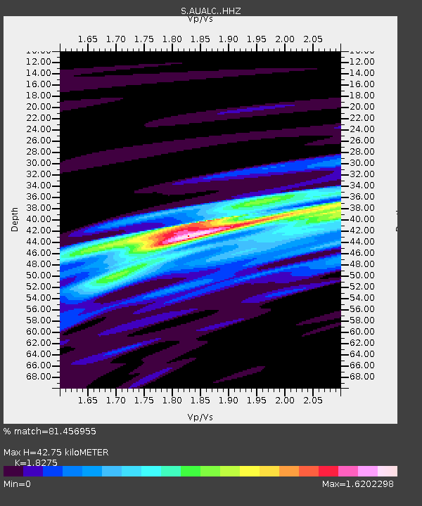
| Estimated Moho Depth: |
42.75 km |
| Estimated Crust Vp/Vs: |
1.83 |
| Assumed Crust Vp: |
6.518 km/s |
| Estimated Crust Vs: |
3.567 km/s |
| Estimated Crust Poisson's Ratio: |
0.29 |
|
| Radial Match: |
81.456955 % |
| Radial Bump: |
400 |
| Transverse Match: |
57.919785 % |
| Transverse Bump: |
400 |
| SOD ConfigId: |
7422571 |
| Insert Time: |
2019-04-21 15:14:48.855 +0000 |
| GWidth: |
2.5 |
| Max Bumps: |
400 |
| Tol: |
0.001 |
|

Signal To Noise
| Channel | StoN | STA | LTA |
| S:AUALC: :HHZ:20151220T18:53:26.790002Z | 17.051151 | 3.1644195E-6 | 1.8558393E-7 |
| S:AUALC: :HHN:20151220T18:53:26.790002Z | 6.8983297 | 1.9318645E-6 | 2.8004814E-7 |
| S:AUALC: :HHE:20151220T18:53:26.790002Z | 3.756218 | 1.16274E-6 | 3.0955073E-7 |
| Arrivals |
| Ps | 5.9 SECOND |
| PpPs | 17 SECOND |
| PsPs/PpSs | 23 SECOND |


