You are here: Home > Network List > S - Seismographs in Schools Projects Stations List
> Station AUPHS Peel High School, NSW, Australia > Earthquake Result Viewer
AUPHS Peel High School, NSW, Australia - Earthquake Result Viewer
| Earthquake location: |
Borneo |
| Earthquake latitude/longitude: |
3.6/117.6 |
| Earthquake time(UTC): |
2015/12/20 (354) 18:47:35 GMT |
| Earthquake Depth: |
9.0 km |
| Earthquake Magnitude: |
6.0 MWP |
| Earthquake Catalog/Contributor: |
NEIC PDE/NEIC COMCAT |
|
| Network: |
S Seismographs in Schools Projects |
| Station: |
AUPHS Peel High School, NSW, Australia |
| Lat/Lon: |
31.10 S/150.89 E |
| Elevation: |
404 m |
|
| Distance: |
46.9 deg |
| Az: |
139.864 deg |
| Baz: |
311.412 deg |
| Ray Param: |
0.07035954 |
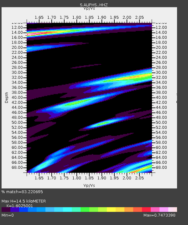
| Estimated Moho Depth: |
14.5 km |
| Estimated Crust Vp/Vs: |
1.60 |
| Assumed Crust Vp: |
6.577 km/s |
| Estimated Crust Vs: |
4.104 km/s |
| Estimated Crust Poisson's Ratio: |
0.18 |
|
| Radial Match: |
83.220695 % |
| Radial Bump: |
259 |
| Transverse Match: |
62.826378 % |
| Transverse Bump: |
400 |
| SOD ConfigId: |
7422571 |
| Insert Time: |
2019-04-21 15:14:54.573 +0000 |
| GWidth: |
2.5 |
| Max Bumps: |
400 |
| Tol: |
0.001 |
|

Signal To Noise
| Channel | StoN | STA | LTA |
| S:AUPHS: :HHZ:20151220T18:55:35.420007Z | 9.00334 | 2.413122E-6 | 2.6802522E-7 |
| S:AUPHS: :HHN:20151220T18:55:35.420007Z | 3.417141 | 1.0409902E-6 | 3.046378E-7 |
| S:AUPHS: :HHE:20151220T18:55:35.420007Z | 3.063556 | 8.3246744E-7 | 2.717324E-7 |
| Arrivals |
| Ps | 1.4 SECOND |
| PpPs | 5.3 SECOND |
| PsPs/PpSs | 6.8 SECOND |


