You are here: Home > Network List > S - Seismographs in Schools Projects Stations List
> Station AUWSH Wavell State High School, QLD > Earthquake Result Viewer
AUWSH Wavell State High School, QLD - Earthquake Result Viewer
| Earthquake location: |
Borneo |
| Earthquake latitude/longitude: |
3.6/117.6 |
| Earthquake time(UTC): |
2015/12/20 (354) 18:47:35 GMT |
| Earthquake Depth: |
9.0 km |
| Earthquake Magnitude: |
6.0 MWP |
| Earthquake Catalog/Contributor: |
NEIC PDE/NEIC COMCAT |
|
| Network: |
S Seismographs in Schools Projects |
| Station: |
AUWSH Wavell State High School, QLD |
| Lat/Lon: |
27.40 S/153.04 E |
| Elevation: |
60 m |
|
| Distance: |
46.0 deg |
| Az: |
134.282 deg |
| Baz: |
306.523 deg |
| Ray Param: |
0.07090376 |
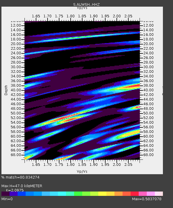
| Estimated Moho Depth: |
47.0 km |
| Estimated Crust Vp/Vs: |
2.10 |
| Assumed Crust Vp: |
6.472 km/s |
| Estimated Crust Vs: |
3.086 km/s |
| Estimated Crust Poisson's Ratio: |
0.35 |
|
| Radial Match: |
80.834274 % |
| Radial Bump: |
400 |
| Transverse Match: |
66.56585 % |
| Transverse Bump: |
400 |
| SOD ConfigId: |
7422571 |
| Insert Time: |
2019-04-21 15:15:00.113 +0000 |
| GWidth: |
2.5 |
| Max Bumps: |
400 |
| Tol: |
0.001 |
|

Signal To Noise
| Channel | StoN | STA | LTA |
| S:AUWSH: :HHZ:20151220T18:55:28.640009Z | 12.840325 | 2.8756122E-6 | 2.2395164E-7 |
| S:AUWSH: :HHN:20151220T18:55:28.640009Z | 4.9382687 | 8.031475E-7 | 1.6263746E-7 |
| S:AUWSH: :HHE:20151220T18:55:28.640009Z | 4.5998354 | 1.2417022E-6 | 2.699449E-7 |
| Arrivals |
| Ps | 8.4 SECOND |
| PpPs | 21 SECOND |
| PsPs/PpSs | 30 SECOND |


