You are here: Home > Network List > TA - USArray Transportable Network (new EarthScope stations) Stations List
> Station A21K Barrow, AK, USA > Earthquake Result Viewer
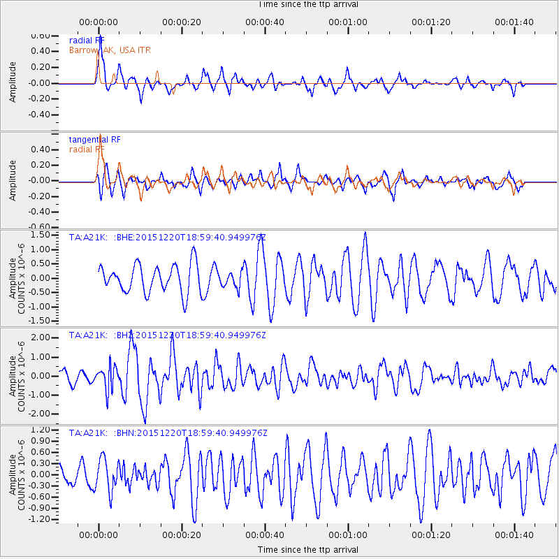
A21K Barrow, AK, USA - Earthquake Result Viewer
*The percent match for this event was below the threshold and hence no stack was calculated.
| Earthquake location: |
Borneo |
| Earthquake latitude/longitude: |
3.6/117.6 |
| Earthquake time(UTC): |
2015/12/20 (354) 18:47:35 GMT |
| Earthquake Depth: |
9.0 km |
| Earthquake Magnitude: |
6.0 MWP |
| Earthquake Catalog/Contributor: |
NEIC PDE/NEIC COMCAT |
|
| Network: |
TA USArray Transportable Network (new EarthScope stations) |
| Station: |
A21K Barrow, AK, USA |
| Lat/Lon: |
71.32 N/156.62 W |
| Elevation: |
577 m |
|
| Distance: |
85.2 deg |
| Az: |
18.809 deg |
| Baz: |
267.146 deg |
| Ray Param: |
$rayparam |
*The percent match for this event was below the threshold and hence was not used in the summary stack. |
|
| Radial Match: |
74.57217 % |
| Radial Bump: |
363 |
| Transverse Match: |
71.69497 % |
| Transverse Bump: |
400 |
| SOD ConfigId: |
7422571 |
| Insert Time: |
2019-04-21 15:15:06.957 +0000 |
| GWidth: |
2.5 |
| Max Bumps: |
400 |
| Tol: |
0.001 |
|
Signal To Noise
| Channel | StoN | STA | LTA |
| TA:A21K: :BHZ:20151220T18:59:40.949976Z | 2.178483 | 6.146733E-7 | 2.8215655E-7 |
| TA:A21K: :BHN:20151220T18:59:40.949976Z | 0.9556922 | 4.3991412E-7 | 4.6030942E-7 |
| TA:A21K: :BHE:20151220T18:59:40.949976Z | 0.58154815 | 2.8373498E-7 | 4.8789593E-7 |
| Arrivals |
| Ps | |
| PpPs | |
| PsPs/PpSs | |


