You are here: Home > Network List > TA - USArray Transportable Network (new EarthScope stations) Stations List
> Station M31M Drury Creek, Yukon, CA > Earthquake Result Viewer
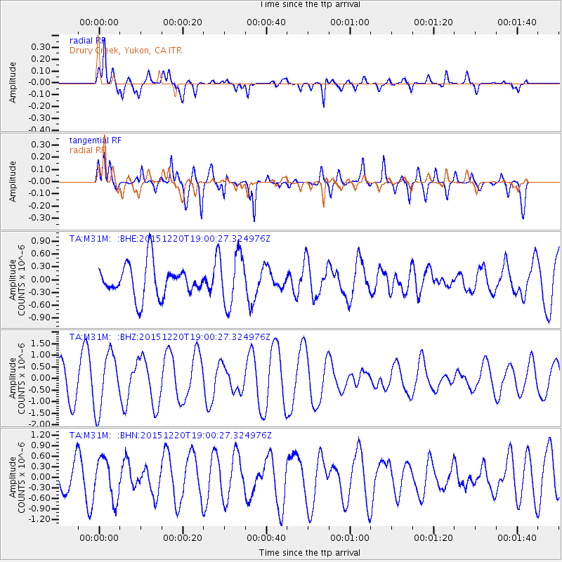
M31M Drury Creek, Yukon, CA - Earthquake Result Viewer
*The percent match for this event was below the threshold and hence no stack was calculated.
| Earthquake location: |
Borneo |
| Earthquake latitude/longitude: |
3.6/117.6 |
| Earthquake time(UTC): |
2015/12/20 (354) 18:47:35 GMT |
| Earthquake Depth: |
9.0 km |
| Earthquake Magnitude: |
6.0 MWP |
| Earthquake Catalog/Contributor: |
NEIC PDE/NEIC COMCAT |
|
| Network: |
TA USArray Transportable Network (new EarthScope stations) |
| Station: |
M31M Drury Creek, Yukon, CA |
| Lat/Lon: |
62.20 N/134.39 W |
| Elevation: |
639 m |
|
| Distance: |
95.1 deg |
| Az: |
26.594 deg |
| Baz: |
287.631 deg |
| Ray Param: |
$rayparam |
*The percent match for this event was below the threshold and hence was not used in the summary stack. |
|
| Radial Match: |
67.529 % |
| Radial Bump: |
400 |
| Transverse Match: |
79.23232 % |
| Transverse Bump: |
400 |
| SOD ConfigId: |
7422571 |
| Insert Time: |
2019-04-21 15:15:12.370 +0000 |
| GWidth: |
2.5 |
| Max Bumps: |
400 |
| Tol: |
0.001 |
|
Signal To Noise
| Channel | StoN | STA | LTA |
| TA:M31M: :BHZ:20151220T19:00:27.324976Z | 2.3979394 | 1.2260816E-6 | 5.1130627E-7 |
| TA:M31M: :BHN:20151220T19:00:27.324976Z | 1.6866237 | 5.776208E-7 | 3.4247165E-7 |
| TA:M31M: :BHE:20151220T19:00:27.324976Z | 1.5981624 | 5.994919E-7 | 3.7511325E-7 |
| Arrivals |
| Ps | |
| PpPs | |
| PsPs/PpSs | |


