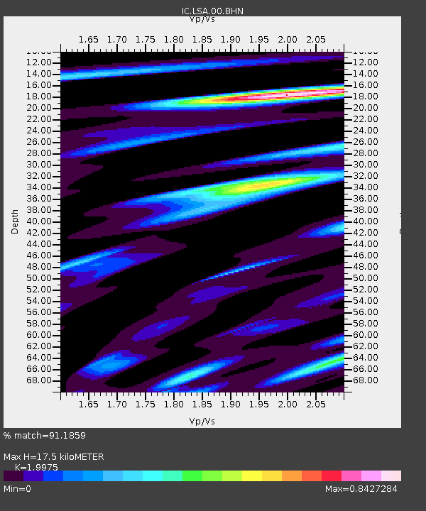
LSA Tibet, China - Earthquake Result Viewer
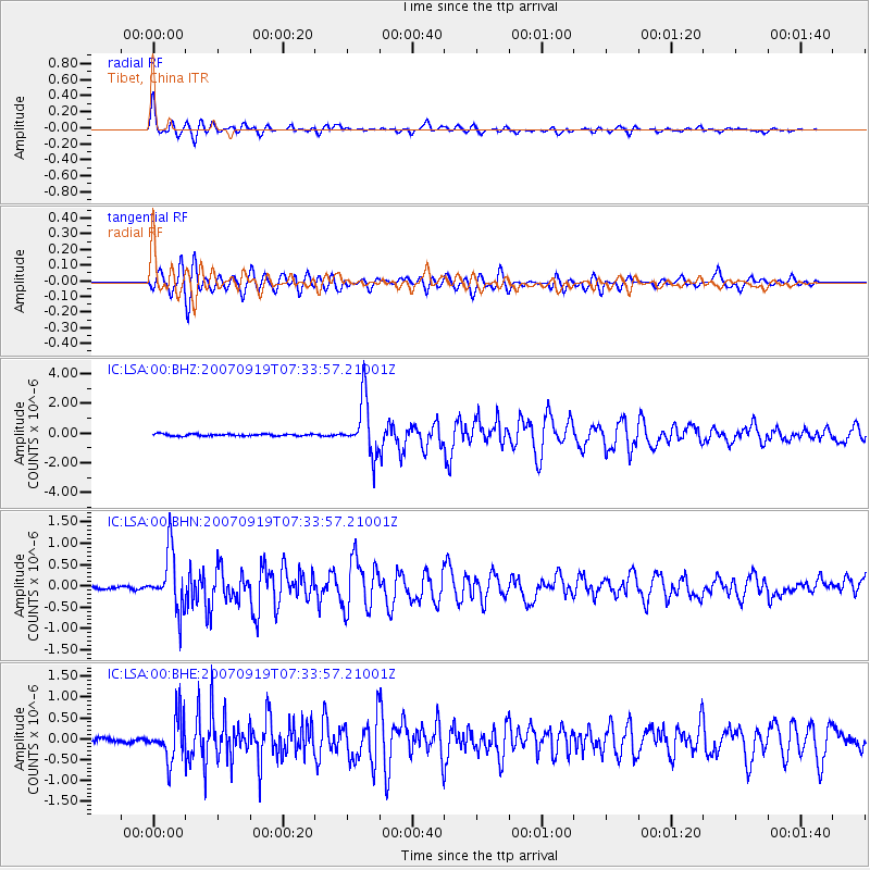
Earthquake location: Southern Sumatra, Indonesia
Earthquake latitude/longitude: -2.7/100.9
Earthquake time(UTC): 2007/09/19 (262) 07:27:50 GMT
Earthquake Depth: 35 km
Earthquake Magnitude: 5.7 MB, 5.8 MS, 6.0 MW, 5.9 MW
Earthquake Catalog/Contributor: WHDF/NEIC
Network: IC New China Digital Seismograph Network
Station: LSA Tibet, China
Lat/Lon: 29.70 N/91.15 E
Elevation: 3789 m
Distance: 33.6 deg
Az: 344.564 deg
Baz: 162.208 deg
Ray Param: 0.078082465
Estimated Moho Depth: 17.5 km
Estimated Crust Vp/Vs: 2.00
Assumed Crust Vp: 6.514 km/s
Estimated Crust Vs: 3.261 km/s
Estimated Crust Poisson's Ratio: 0.33
Radial Match: 91.1859 %
Radial Bump: 400
Transverse Match: 83.31654 %
Transverse Bump: 400
SOD ConfigId: 2564
Insert Time: 2010-03-04 22:50:34.526 +0000
GWidth: 2.5
Max Bumps: 400
Tol: 0.001

Signal To Noise

ChannelStoNSTALTA
IC:LSA:00:BHN:20070919T07:33:57.21001Z21.2245676.6883075E-73.1512105E-8
IC:LSA:00:BHE:20070919T07:33:57.21001Z10.157855.23524E-75.1538862E-8
IC:LSA:00:BHZ:20070919T07:33:57.21001Z27.3551481.8397272E-66.725342E-8
Arrivals
Ps2.9 SECOND
PpPs7.5 SECOND
PsPs/PpSs10 SECOND