You are here: Home > Network List > XL12 - Hangay Dome, Mongolia Stations List
> Station HV21 HV21 > Earthquake Result Viewer
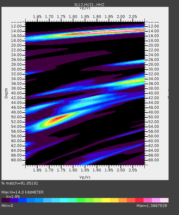
HV21 HV21 - Earthquake Result Viewer
| Earthquake location: |
Borneo |
| Earthquake latitude/longitude: |
3.6/117.6 |
| Earthquake time(UTC): |
2015/12/20 (354) 18:47:35 GMT |
| Earthquake Depth: |
9.0 km |
| Earthquake Magnitude: |
6.0 MWP |
| Earthquake Catalog/Contributor: |
NEIC PDE/NEIC COMCAT |
|
| Network: |
XL Hangay Dome, Mongolia |
| Station: |
HV21 HV21 |
| Lat/Lon: |
51.43 N/100.78 E |
| Elevation: |
1677 m |
|
| Distance: |
49.7 deg |
| Az: |
346.233 deg |
| Baz: |
157.706 deg |
| Ray Param: |
0.06855046 |
| Estimated Moho Depth: |
14.0 km |
| Estimated Crust Vp/Vs: |
1.95 |
| Assumed Crust Vp: |
6.419 km/s |
| Estimated Crust Vs: |
3.292 km/s |
| Estimated Crust Poisson's Ratio: |
0.32 |
|
| Radial Match: |
91.85181 % |
| Radial Bump: |
341 |
| Transverse Match: |
76.78205 % |
| Transverse Bump: |
400 |
| SOD ConfigId: |
7422571 |
| Insert Time: |
2019-04-21 15:15:45.889 +0000 |
| GWidth: |
2.5 |
| Max Bumps: |
400 |
| Tol: |
0.001 |
|

Signal To Noise
| Channel | StoN | STA | LTA |
| XL:HV21: :HHZ:20151220T18:55:56.839014Z | 4.71516 | 2.5638982E-7 | 5.437564E-8 |
| XL:HV21: :HHN:20151220T18:55:56.839014Z | 2.3585749 | 1.7986208E-7 | 7.62588E-8 |
| XL:HV21: :HHE:20151220T18:55:56.839014Z | 0.9289458 | 1.212996E-7 | 1.305777E-7 |
| Arrivals |
| Ps | 2.2 SECOND |
| PpPs | 6.1 SECOND |
| PsPs/PpSs | 8.3 SECOND |


