You are here: Home > Network List > IC - New China Digital Seismograph Network Stations List
> Station LSA Tibet, China > Earthquake Result Viewer
LSA Tibet, China - Earthquake Result Viewer
| Earthquake location: |
Banda Sea |
| Earthquake latitude/longitude: |
-6.7/129.1 |
| Earthquake time(UTC): |
2008/11/07 (312) 16:04:23 GMT |
| Earthquake Depth: |
10 km |
| Earthquake Magnitude: |
5.9 MB, 5.9 MS, 6.2 MW, 6.2 MW |
| Earthquake Catalog/Contributor: |
WHDF/NEIC |
|
| Network: |
IC New China Digital Seismograph Network |
| Station: |
LSA Tibet, China |
| Lat/Lon: |
29.70 N/91.15 E |
| Elevation: |
3789 m |
|
| Distance: |
51.4 deg |
| Az: |
316.793 deg |
| Baz: |
128.595 deg |
| Ray Param: |
0.06746435 |
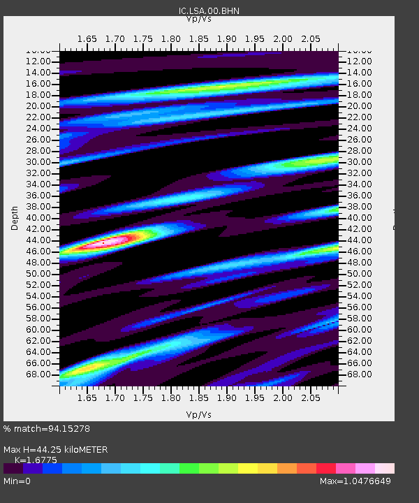
| Estimated Moho Depth: |
44.25 km |
| Estimated Crust Vp/Vs: |
1.68 |
| Assumed Crust Vp: |
6.514 km/s |
| Estimated Crust Vs: |
3.883 km/s |
| Estimated Crust Poisson's Ratio: |
0.22 |
|
| Radial Match: |
94.15278 % |
| Radial Bump: |
376 |
| Transverse Match: |
87.70267 % |
| Transverse Bump: |
400 |
| SOD ConfigId: |
2658 |
| Insert Time: |
2010-03-04 22:51:09.258 +0000 |
| GWidth: |
2.5 |
| Max Bumps: |
400 |
| Tol: |
0.001 |
|
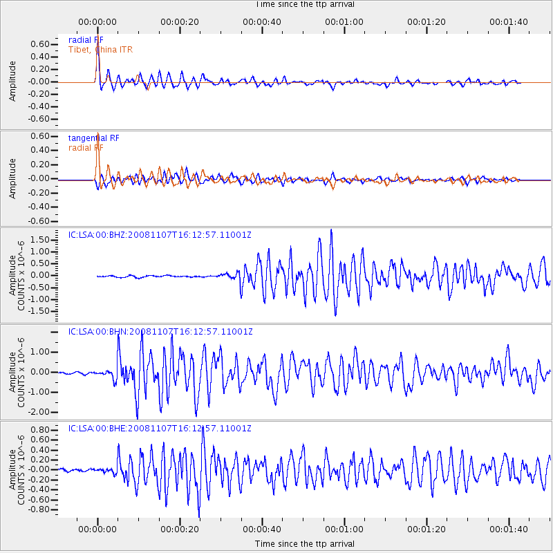
Signal To Noise
| Channel | StoN | STA | LTA |
| IC:LSA:00:BHN:20081107T16:12:57.11001Z | 4.5213017 | 2.501729E-7 | 5.5332052E-8 |
| IC:LSA:00:BHE:20081107T16:12:57.11001Z | 2.7722063 | 4.8543264E-8 | 1.7510697E-8 |
| IC:LSA:00:BHZ:20081107T16:12:57.11001Z | 3.3379347 | 1.062509E-7 | 3.1831327E-8 |
| Arrivals |
| Ps | 4.9 SECOND |
| PpPs | 17 SECOND |
| PsPs/PpSs | 22 SECOND |


