You are here: Home > Network List > IC - New China Digital Seismograph Network Stations List
> Station LSA Tibet, China > Earthquake Result Viewer
LSA Tibet, China - Earthquake Result Viewer
| Earthquake location: |
Southern Sumatra, Indonesia |
| Earthquake latitude/longitude: |
-4.3/101.3 |
| Earthquake time(UTC): |
2008/11/22 (327) 16:01:01 GMT |
| Earthquake Depth: |
24 km |
| Earthquake Magnitude: |
5.9 MB, 6.4 MW, 6.3 MW |
| Earthquake Catalog/Contributor: |
WHDF/NEIC |
|
| Network: |
IC New China Digital Seismograph Network |
| Station: |
LSA Tibet, China |
| Lat/Lon: |
29.70 N/91.15 E |
| Elevation: |
3789 m |
|
| Distance: |
35.2 deg |
| Az: |
344.643 deg |
| Baz: |
162.331 deg |
| Ray Param: |
0.07730562 |
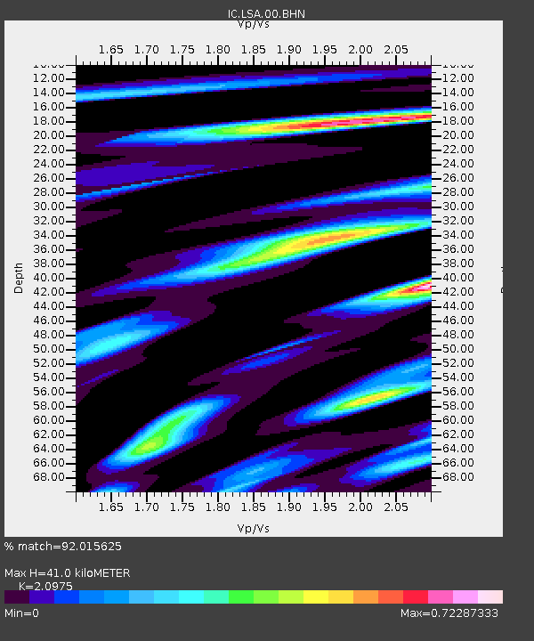
| Estimated Moho Depth: |
41.0 km |
| Estimated Crust Vp/Vs: |
2.10 |
| Assumed Crust Vp: |
6.514 km/s |
| Estimated Crust Vs: |
3.106 km/s |
| Estimated Crust Poisson's Ratio: |
0.35 |
|
| Radial Match: |
92.015625 % |
| Radial Bump: |
400 |
| Transverse Match: |
83.887535 % |
| Transverse Bump: |
400 |
| SOD ConfigId: |
2658 |
| Insert Time: |
2010-03-04 22:51:13.309 +0000 |
| GWidth: |
2.5 |
| Max Bumps: |
400 |
| Tol: |
0.001 |
|
Signal To Noise
| Channel | StoN | STA | LTA |
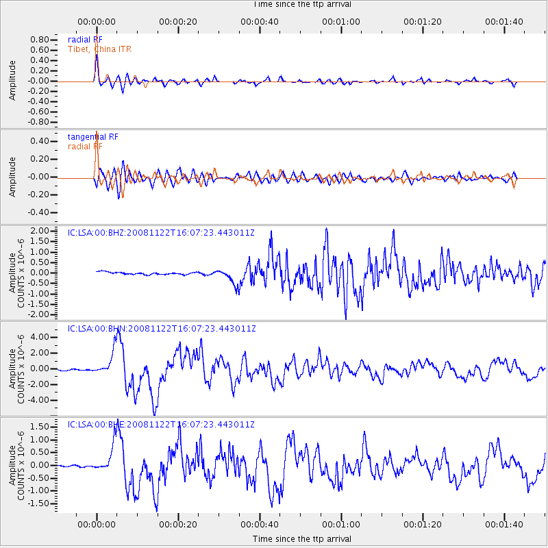
| IC:LSA:00:BHN:20081122T16:07:23.443011Z | 18.824474 | 1.5733937E-6 | 8.358234E-8 |
| IC:LSA:00:BHE:20081122T16:07:23.443011Z | 21.889128 | 5.506388E-7 | 2.5155812E-8 |
| IC:LSA:00:BHZ:20081122T16:07:23.443011Z | 6.2536645 | 3.4772998E-7 | 5.5604193E-8 |
| Arrivals |
| Ps | 7.4 SECOND |
| PpPs | 18 SECOND |
| PsPs/PpSs | 26 SECOND |


