You are here: Home > Network List > CI - Caltech Regional Seismic Network Stations List
> Station VES Vestal, Porterville, CA, USA > Earthquake Result Viewer
VES Vestal, Porterville, CA, USA - Earthquake Result Viewer
| Earthquake location: |
Near S. Coast Of Honshu, Japan |
| Earthquake latitude/longitude: |
33.2/137.1 |
| Earthquake time(UTC): |
2004/09/05 (249) 14:57:18 GMT |
| Earthquake Depth: |
10 km |
| Earthquake Magnitude: |
6.2 MB, 7.1 MS, 7.4 MW, 7.4 MW |
| Earthquake Catalog/Contributor: |
WHDF/NEIC |
|
| Network: |
CI Caltech Regional Seismic Network |
| Station: |
VES Vestal, Porterville, CA, USA |
| Lat/Lon: |
35.84 N/119.08 W |
| Elevation: |
154 m |
|
| Distance: |
81.1 deg |
| Az: |
52.987 deg |
| Baz: |
304.499 deg |
| Ray Param: |
0.047816645 |
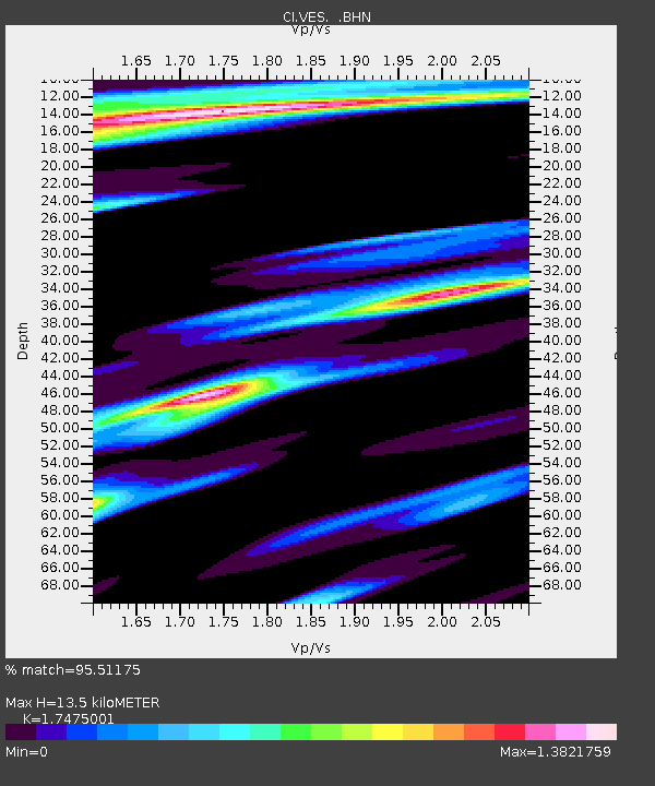
| Estimated Moho Depth: |
13.5 km |
| Estimated Crust Vp/Vs: |
1.75 |
| Assumed Crust Vp: |
6.1 km/s |
| Estimated Crust Vs: |
3.491 km/s |
| Estimated Crust Poisson's Ratio: |
0.26 |
|
| Radial Match: |
95.51175 % |
| Radial Bump: |
394 |
| Transverse Match: |
87.88513 % |
| Transverse Bump: |
400 |
| SOD ConfigId: |
2459 |
| Insert Time: |
2010-02-26 00:01:53.236 +0000 |
| GWidth: |
2.5 |
| Max Bumps: |
400 |
| Tol: |
0.001 |
|

Signal To Noise
| Channel | StoN | STA | LTA |
| CI:VES: :BHN:20040905T15:09:02.570999Z | 2.3983974 | 2.3754285E-6 | 9.904232E-7 |
| CI:VES: :BHE:20040905T15:09:02.570999Z | 1.8565154 | 1.1673604E-6 | 6.2879116E-7 |
| CI:VES: :BHZ:20040905T15:09:02.570999Z | 3.1611273 | 8.912506E-7 | 2.8194074E-7 |
| Arrivals |
| Ps | 1.7 SECOND |
| PpPs | 5.9 SECOND |
| PsPs/PpSs | 7.6 SECOND |


