You are here: Home > Network List > IC - New China Digital Seismograph Network Stations List
> Station LSA Tibet, China > Earthquake Result Viewer
LSA Tibet, China - Earthquake Result Viewer
| Earthquake location: |
South Of Java, Indonesia |
| Earthquake latitude/longitude: |
-10.2/110.6 |
| Earthquake time(UTC): |
2009/09/07 (250) 16:12:22 GMT |
| Earthquake Depth: |
23 km |
| Earthquake Magnitude: |
6.1 MB, 5.9 MS, 6.2 MW, 6.1 MW |
| Earthquake Catalog/Contributor: |
WHDF/NEIC |
|
| Network: |
IC New China Digital Seismograph Network |
| Station: |
LSA Tibet, China |
| Lat/Lon: |
29.70 N/91.15 E |
| Elevation: |
3789 m |
|
| Distance: |
43.9 deg |
| Az: |
335.258 deg |
| Baz: |
151.736 deg |
| Ray Param: |
0.072226144 |
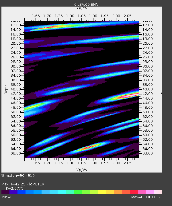
| Estimated Moho Depth: |
42.25 km |
| Estimated Crust Vp/Vs: |
2.08 |
| Assumed Crust Vp: |
6.514 km/s |
| Estimated Crust Vs: |
3.136 km/s |
| Estimated Crust Poisson's Ratio: |
0.35 |
|
| Radial Match: |
90.4919 % |
| Radial Bump: |
400 |
| Transverse Match: |
85.45505 % |
| Transverse Bump: |
400 |
| SOD ConfigId: |
2622 |
| Insert Time: |
2010-03-04 22:51:28.912 +0000 |
| GWidth: |
2.5 |
| Max Bumps: |
400 |
| Tol: |
0.001 |
|
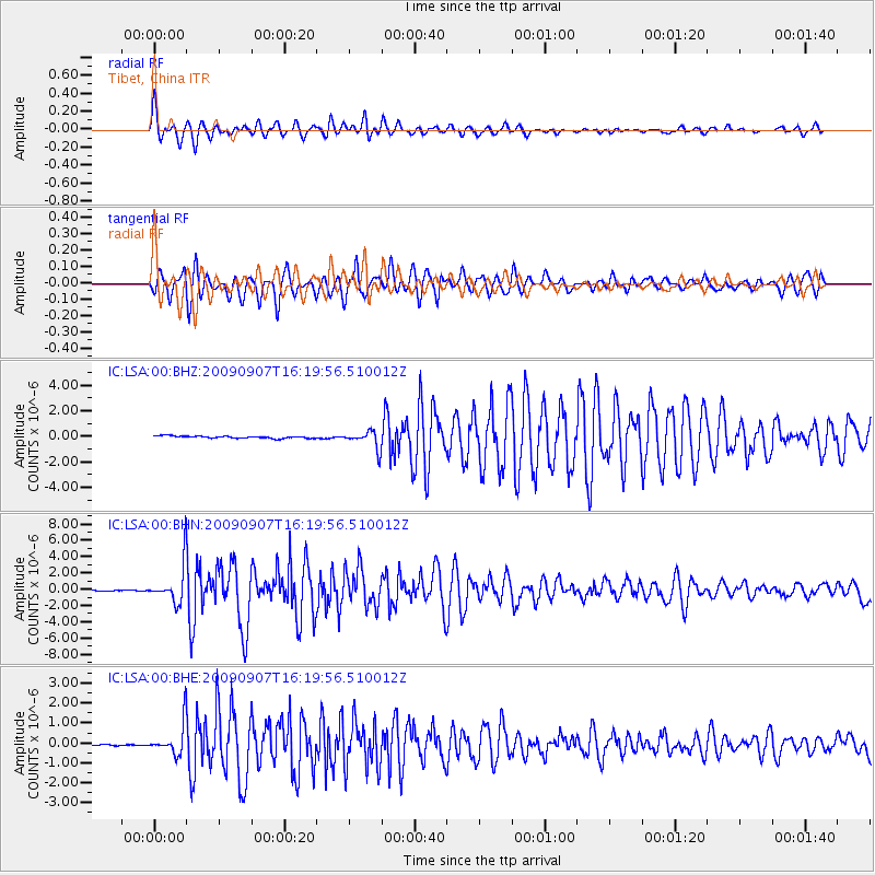
Signal To Noise
| Channel | StoN | STA | LTA |
| IC:LSA:00:BHN:20090907T16:19:56.510012Z | 38.80751 | 2.395516E-6 | 6.172815E-8 |
| IC:LSA:00:BHE:20090907T16:19:56.510012Z | 22.193922 | 8.0877203E-7 | 3.644115E-8 |
| IC:LSA:00:BHZ:20090907T16:19:56.510012Z | 7.8375196 | 6.820206E-7 | 8.7019956E-8 |
| Arrivals |
| Ps | 7.4 SECOND |
| PpPs | 19 SECOND |
| PsPs/PpSs | 26 SECOND |


