You are here: Home > Network List > CI - Caltech Regional Seismic Network Stations List
> Station VES Vestal, Porterville, CA, USA > Earthquake Result Viewer
VES Vestal, Porterville, CA, USA - Earthquake Result Viewer

| Earthquake location: |
South Pacific Ocean |
| Earthquake latitude/longitude: |
-20.3/-126.9 |
| Earthquake time(UTC): |
2004/07/11 (193) 23:46:12 GMT |
| Earthquake Depth: |
12 km |
| Earthquake Magnitude: |
6.1 MB, 5.9 MS, 6.1 MW, 6.1 MW |
| Earthquake Catalog/Contributor: |
WHDF/NEIC |
|
| Network: |
CI Caltech Regional Seismic Network |
| Station: |
VES Vestal, Porterville, CA, USA |
| Lat/Lon: |
35.84 N/119.08 W |
| Elevation: |
154 m |
|
| Distance: |
56.3 deg |
| Az: |
7.661 deg |
| Baz: |
188.862 deg |
| Ray Param: |
0.06424094 |
| Estimated Moho Depth: |
53.0 km |
| Estimated Crust Vp/Vs: |
1.66 |
| Assumed Crust Vp: |
6.1 km/s |
| Estimated Crust Vs: |
3.669 km/s |
| Estimated Crust Poisson's Ratio: |
0.22 |
|
| Radial Match: |
82.09115 % |
| Radial Bump: |
400 |
| Transverse Match: |
84.111084 % |
| Transverse Bump: |
400 |
| SOD ConfigId: |
2459 |
| Insert Time: |
2010-02-26 00:01:57.093 +0000 |
| GWidth: |
2.5 |
| Max Bumps: |
400 |
| Tol: |
0.001 |
|
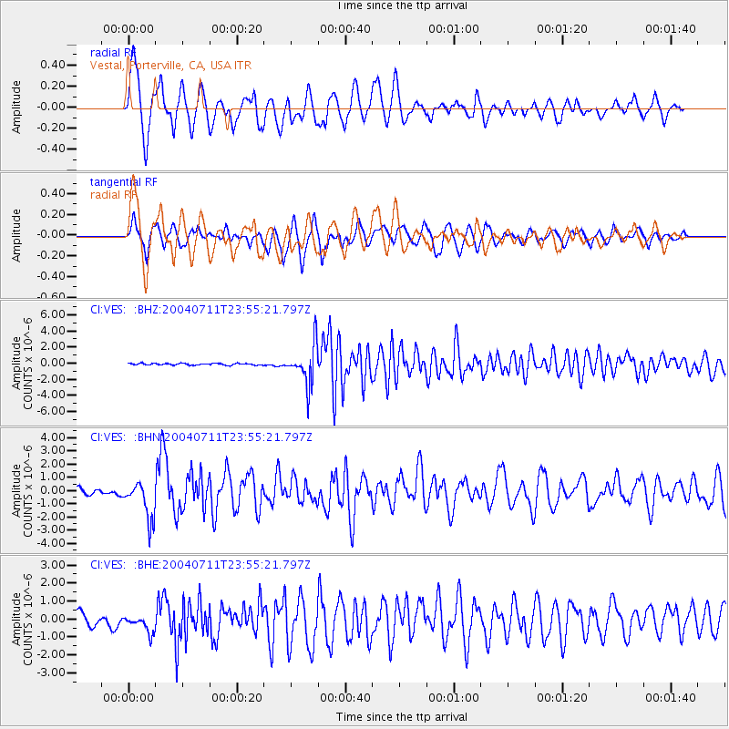
Signal To Noise
| Channel | StoN | STA | LTA |
| CI:VES: :BHN:20040711T23:55:21.797Z | 4.714501 | 1.4493078E-6 | 3.0741487E-7 |
| CI:VES: :BHE:20040711T23:55:21.797Z | 1.5571474 | 5.217161E-7 | 3.3504605E-7 |
| CI:VES: :BHZ:20040711T23:55:21.797Z | 23.150507 | 2.4351393E-6 | 1.05187304E-7 |
| Arrivals |
| Ps | 6.0 SECOND |
| PpPs | 22 SECOND |
| PsPs/PpSs | 28 SECOND |


