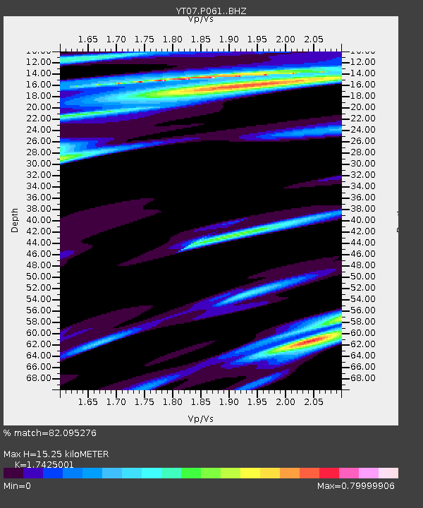
P061 P061 - Earthquake Result Viewer

Earthquake location: Southern East Pacific Rise
Earthquake latitude/longitude: -55.8/-123.1
Earthquake time(UTC): 2015/12/24 (358) 19:44:03 GMT
Earthquake Depth: 12 km
Earthquake Magnitude: 6.2 MWW, 6.1 MWB, 6.2 MWC
Earthquake Catalog/Contributor: NEIC PDE/NEIC COMCAT
Network: YT POLENET
Station: P061 P061
Lat/Lon: 84.50 S/77.22 E
Elevation: 1758 m
Distance: 39.7 deg
Az: 183.013 deg
Baz: 162.067 deg
Ray Param: 0.07485203
Estimated Moho Depth: 15.25 km
Estimated Crust Vp/Vs: 1.74
Assumed Crust Vp: 6.261 km/s
Estimated Crust Vs: 3.593 km/s
Estimated Crust Poisson's Ratio: 0.25
Radial Match: 82.095276 %
Radial Bump: 400
Transverse Match: 62.69653 %
Transverse Bump: 400
SOD ConfigId: 7422571
Insert Time: 2019-04-21 15:30:19.169 +0000
GWidth: 2.5
Max Bumps: 400
Tol: 0.001

Signal To Noise

ChannelStoNSTALTA
YT:P061: :BHZ:20151224T19:51:03.899989Z2.36860754.284522E-71.8088781E-7
YT:P061: :BHN:20151224T19:51:03.899989Z2.30669122.0951501E-79.082924E-8
YT:P061: :BHE:20151224T19:51:03.899989Z1.23352731.4888316E-71.206971E-7
Arrivals
Ps1.9 SECOND
PpPs6.2 SECOND
PsPs/PpSs8.2 SECOND