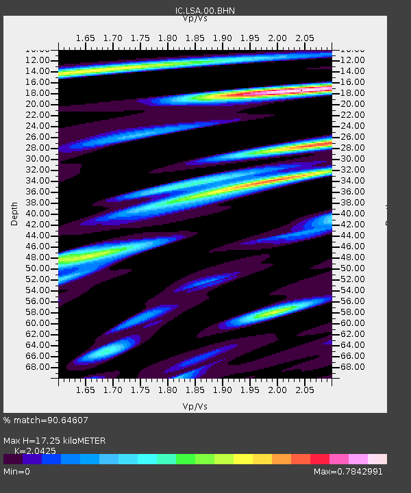
LSA Tibet, China - Earthquake Result Viewer
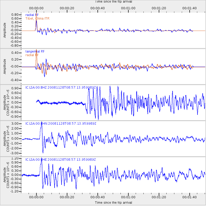
Earthquake location: Southern Sumatra, Indonesia
Earthquake latitude/longitude: -4.7/101.8
Earthquake time(UTC): 2008/11/28 (333) 08:50:48 GMT
Earthquake Depth: 27 km
Earthquake Magnitude: 5.7 MB, 5.9 MS, 5.8 MW, 5.8 MW
Earthquake Catalog/Contributor: WHDF/NEIC
Network: IC New China Digital Seismograph Network
Station: LSA Tibet, China
Lat/Lon: 29.70 N/91.15 E
Elevation: 3789 m
Distance: 35.7 deg
Az: 344.086 deg
Baz: 161.694 deg
Ray Param: 0.077027924
Estimated Moho Depth: 17.25 km
Estimated Crust Vp/Vs: 2.04
Assumed Crust Vp: 6.514 km/s
Estimated Crust Vs: 3.189 km/s
Estimated Crust Poisson's Ratio: 0.34
Radial Match: 90.64607 %
Radial Bump: 400
Transverse Match: 81.970924 %
Transverse Bump: 400
SOD ConfigId: 2658
Insert Time: 2010-03-04 22:52:31.719 +0000
GWidth: 2.5
Max Bumps: 400
Tol: 0.001

Signal To Noise

ChannelStoNSTALTA
IC:LSA:00:BHN:20081128T08:57:13.959989Z23.6237751.5085183E-66.3855936E-8
IC:LSA:00:BHE:20081128T08:57:13.959989Z19.4991915.503693E-72.8225237E-8
IC:LSA:00:BHZ:20081128T08:57:13.959989Z7.80552343.978685E-75.0972687E-8
Arrivals
Ps3.0 SECOND
PpPs7.5 SECOND
PsPs/PpSs10 SECOND