You are here: Home > Network List > IC - New China Digital Seismograph Network Stations List
> Station LSA Tibet, China > Earthquake Result Viewer
LSA Tibet, China - Earthquake Result Viewer
| Earthquake location: |
Banda Sea |
| Earthquake latitude/longitude: |
-4.7/126.8 |
| Earthquake time(UTC): |
2006/05/22 (142) 20:53:57 GMT |
| Earthquake Depth: |
2.8 km |
| Earthquake Magnitude: |
5.8 MB, 5.9 MS, 6.1 MW, 6.1 MW |
| Earthquake Catalog/Contributor: |
WHDF/NEIC |
|
| Network: |
IC New China Digital Seismograph Network |
| Station: |
LSA Tibet, China |
| Lat/Lon: |
29.70 N/91.15 E |
| Elevation: |
3789 m |
|
| Distance: |
48.4 deg |
| Az: |
317.266 deg |
| Baz: |
128.982 deg |
| Ray Param: |
0.06942258 |
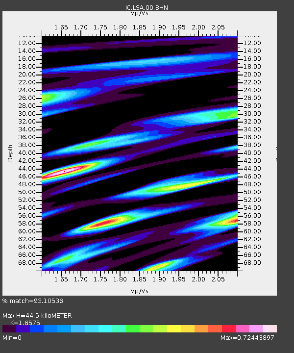
| Estimated Moho Depth: |
44.5 km |
| Estimated Crust Vp/Vs: |
1.66 |
| Assumed Crust Vp: |
6.514 km/s |
| Estimated Crust Vs: |
3.93 km/s |
| Estimated Crust Poisson's Ratio: |
0.21 |
|
| Radial Match: |
93.10536 % |
| Radial Bump: |
400 |
| Transverse Match: |
82.86497 % |
| Transverse Bump: |
400 |
| SOD ConfigId: |
2669 |
| Insert Time: |
2010-03-04 22:52:37.958 +0000 |
| GWidth: |
2.5 |
| Max Bumps: |
400 |
| Tol: |
0.001 |
|
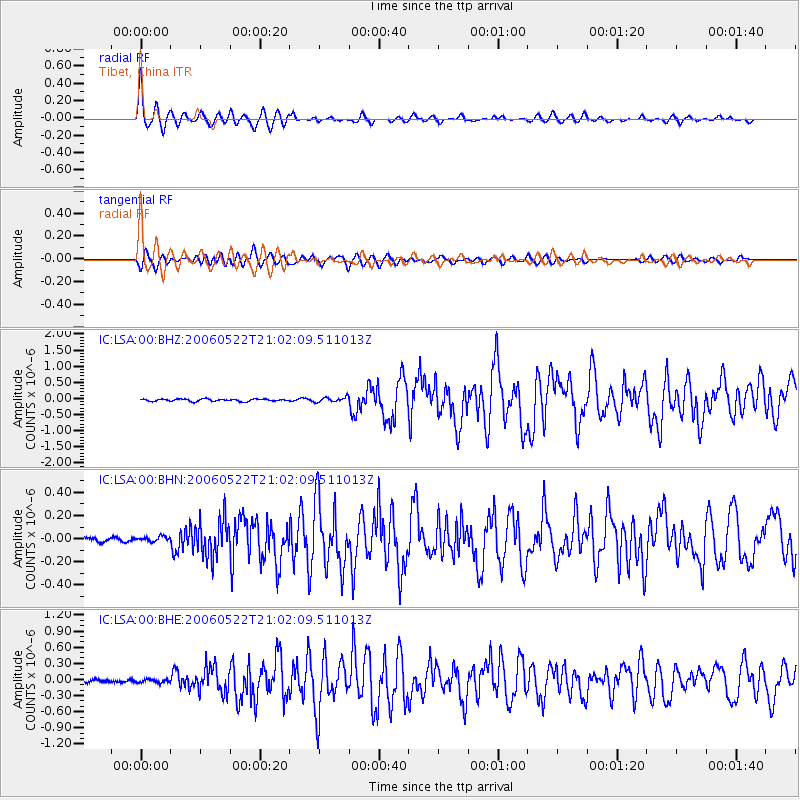
Signal To Noise
| Channel | StoN | STA | LTA |
| IC:LSA:00:BHN:20060522T21:02:09.511013Z | 1.2975444 | 2.4294636E-8 | 1.8723549E-8 |
| IC:LSA:00:BHE:20060522T21:02:09.511013Z | 0.96372974 | 3.097478E-8 | 3.2140523E-8 |
| IC:LSA:00:BHZ:20060522T21:02:09.511013Z | 2.212094 | 7.7129634E-8 | 3.486725E-8 |
| Arrivals |
| Ps | 4.8 SECOND |
| PpPs | 17 SECOND |
| PsPs/PpSs | 22 SECOND |


