You are here: Home > Network List > IC - New China Digital Seismograph Network Stations List
> Station LSA Tibet, China > Earthquake Result Viewer
LSA Tibet, China - Earthquake Result Viewer
| Earthquake location: |
Kyushu, Japan |
| Earthquake latitude/longitude: |
31.8/131.3 |
| Earthquake time(UTC): |
1996/12/02 (337) 22:17:59 GMT |
| Earthquake Depth: |
49 km |
| Earthquake Magnitude: |
6.0 MB, 6.6 MS, 6.8 UNKNOWN, 6.3 ME |
| Earthquake Catalog/Contributor: |
WHDF/NEIC |
|
| Network: |
IC New China Digital Seismograph Network |
| Station: |
LSA Tibet, China |
| Lat/Lon: |
29.70 N/91.15 E |
| Elevation: |
3789 m |
|
| Distance: |
34.4 deg |
| Az: |
277.233 deg |
| Baz: |
76.16 deg |
| Ray Param: |
0.07761847 |
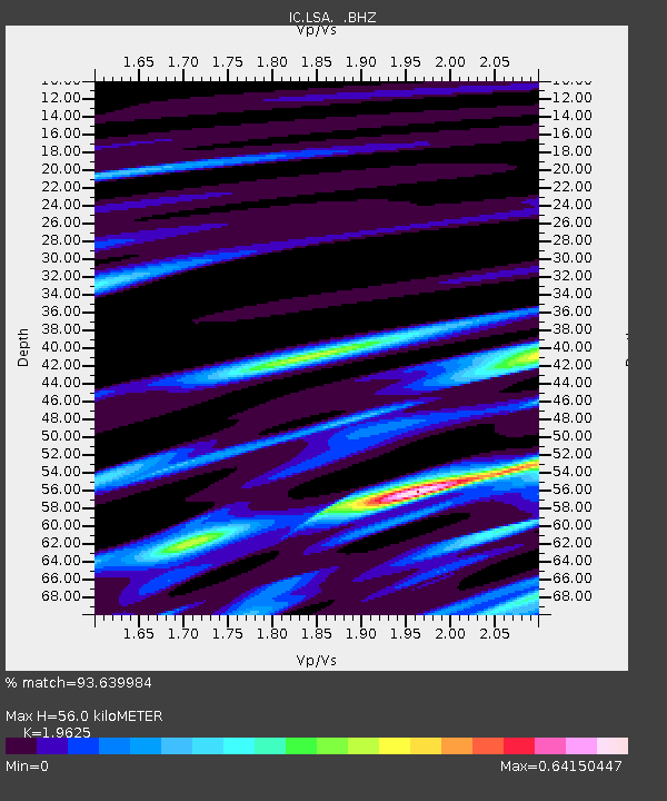
| Estimated Moho Depth: |
56.0 km |
| Estimated Crust Vp/Vs: |
1.96 |
| Assumed Crust Vp: |
6.514 km/s |
| Estimated Crust Vs: |
3.319 km/s |
| Estimated Crust Poisson's Ratio: |
0.32 |
|
| Radial Match: |
93.639984 % |
| Radial Bump: |
363 |
| Transverse Match: |
76.02982 % |
| Transverse Bump: |
400 |
| SOD ConfigId: |
4480 |
| Insert Time: |
2010-03-04 22:52:47.636 +0000 |
| GWidth: |
2.5 |
| Max Bumps: |
400 |
| Tol: |
0.001 |
|

Signal To Noise
| Channel | StoN | STA | LTA |
| IC:LSA: :BHZ:19961202T22:24:12.038989Z | 2.8280292 | 2.2716048E-7 | 8.032467E-8 |
| IC:LSA: :BHN:19961202T22:24:12.038989Z | 0.77577174 | 2.7608717E-8 | 3.5588712E-8 |
| IC:LSA: :BHE:19961202T22:24:12.038989Z | 2.0234063 | 1.05972994E-7 | 5.237356E-8 |
| Arrivals |
| Ps | 8.9 SECOND |
| PpPs | 24 SECOND |
| PsPs/PpSs | 33 SECOND |


