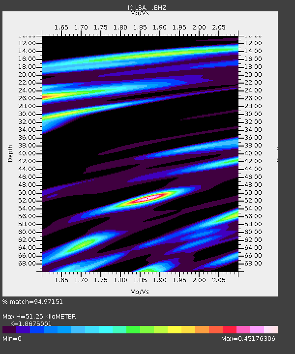
LSA Tibet, China - Earthquake Result Viewer
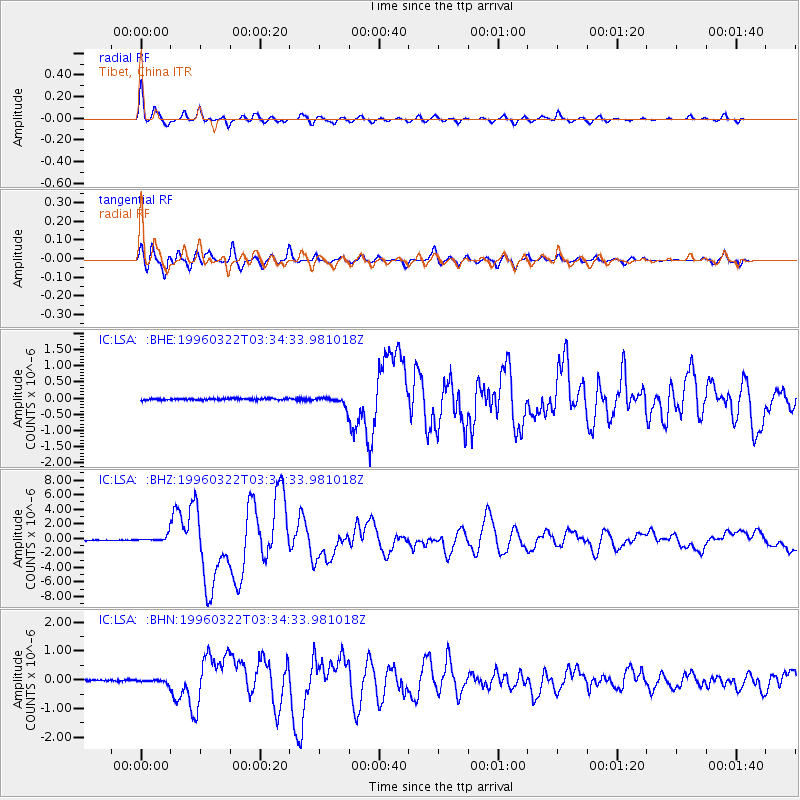
Earthquake location: Rat Islands, Aleutian Islands
Earthquake latitude/longitude: 51.2/178.7
Earthquake time(UTC): 1996/03/22 (082) 03:24:20 GMT
Earthquake Depth: 20 km
Earthquake Magnitude: 5.7 MB, 6.6 MS, 6.8 UNKNOWN, 6.6 ML
Earthquake Catalog/Contributor: WHDF/NEIC
Network: IC New China Digital Seismograph Network
Station: LSA Tibet, China
Lat/Lon: 29.70 N/91.15 E
Elevation: 3789 m
Distance: 66.0 deg
Az: 287.916 deg
Baz: 43.452 deg
Ray Param: 0.057880744
Estimated Moho Depth: 51.25 km
Estimated Crust Vp/Vs: 1.87
Assumed Crust Vp: 6.514 km/s
Estimated Crust Vs: 3.488 km/s
Estimated Crust Poisson's Ratio: 0.30
Radial Match: 94.97151 %
Radial Bump: 400
Transverse Match: 92.469955 %
Transverse Bump: 400
SOD ConfigId: 4480
Insert Time: 2010-03-04 22:53:09.587 +0000
GWidth: 2.5
Max Bumps: 400
Tol: 0.001

Signal To Noise

ChannelStoNSTALTA
IC:LSA: :BHZ:19960322T03:34:33.981018Z8.4454974.5269493E-75.360193E-8
IC:LSA: :BHN:19960322T03:34:33.981018Z1.95569846.370707E-83.2575098E-8
IC:LSA: :BHE:19960322T03:34:33.981018Z4.6215831.2408614E-72.6849275E-8
Arrivals
Ps7.1 SECOND
PpPs22 SECOND
PsPs/PpSs29 SECOND