You are here: Home > Network List > TA - USArray Transportable Network (new EarthScope stations) Stations List
> Station Z41A Richland Creek Farm, El Dorado, AR, USA > Earthquake Result Viewer
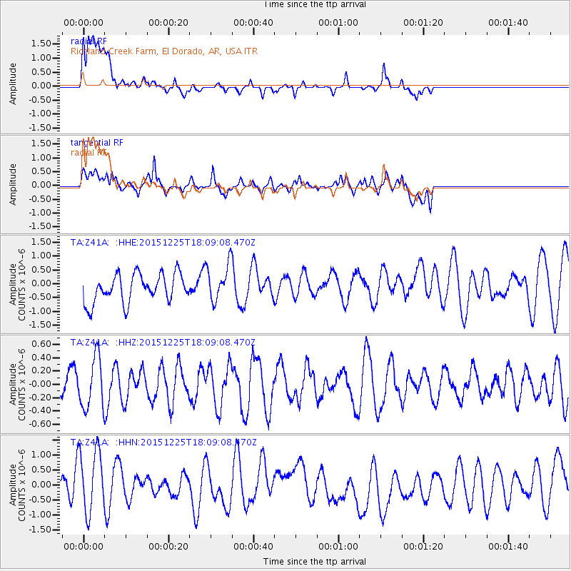
Z41A Richland Creek Farm, El Dorado, AR, USA - Earthquake Result Viewer
*The percent match for this event was below the threshold and hence no stack was calculated.
| Earthquake location: |
West Chile Rise |
| Earthquake latitude/longitude: |
-40.7/-86.4 |
| Earthquake time(UTC): |
2015/12/25 (359) 17:58:04 GMT |
| Earthquake Depth: |
10 km |
| Earthquake Magnitude: |
5.8 MWW, 5.7 MWC, 5.7 MWB |
| Earthquake Catalog/Contributor: |
NEIC PDE/NEIC COMCAT |
|
| Network: |
TA USArray Transportable Network (new EarthScope stations) |
| Station: |
Z41A Richland Creek Farm, El Dorado, AR, USA |
| Lat/Lon: |
33.26 N/92.80 W |
| Elevation: |
62 m |
|
| Distance: |
73.9 deg |
| Az: |
354.448 deg |
| Baz: |
174.966 deg |
| Ray Param: |
$rayparam |
*The percent match for this event was below the threshold and hence was not used in the summary stack. |
|
| Radial Match: |
56.14361 % |
| Radial Bump: |
400 |
| Transverse Match: |
47.241615 % |
| Transverse Bump: |
400 |
| SOD ConfigId: |
7422571 |
| Insert Time: |
2019-04-21 15:40:15.845 +0000 |
| GWidth: |
2.5 |
| Max Bumps: |
400 |
| Tol: |
0.001 |
|
Signal To Noise
| Channel | StoN | STA | LTA |
| TA:Z41A: :HHZ:20151225T18:09:08.470Z | 1.9090577 | 3.8762886E-7 | 2.0304722E-7 |
| TA:Z41A: :HHN:20151225T18:09:08.470Z | 1.7423952 | 1.1551879E-6 | 6.6298844E-7 |
| TA:Z41A: :HHE:20151225T18:09:08.470Z | 1.3156475 | 6.748259E-7 | 5.1292307E-7 |
| Arrivals |
| Ps | |
| PpPs | |
| PsPs/PpSs | |


