You are here: Home > Network List > IU - Global Seismograph Network (GSN - IRIS/USGS) Stations List
> Station PMG Port Moresby, New Guinea > Earthquake Result Viewer
PMG Port Moresby, New Guinea - Earthquake Result Viewer
*The percent match for this event was below the threshold and hence no stack was calculated.
| Earthquake location: |
Kuril Islands |
| Earthquake latitude/longitude: |
47.9/152.5 |
| Earthquake time(UTC): |
2009/10/10 (283) 21:24:38 GMT |
| Earthquake Depth: |
112 km |
| Earthquake Magnitude: |
5.9 MB, 6.0 MW, 6.0 MW |
| Earthquake Catalog/Contributor: |
WHDF/NEIC |
|
| Network: |
IU Global Seismograph Network (GSN - IRIS/USGS) |
| Station: |
PMG Port Moresby, New Guinea |
| Lat/Lon: |
9.40 S/147.16 E |
| Elevation: |
90 m |
|
| Distance: |
57.2 deg |
| Az: |
186.22 deg |
| Baz: |
4.241 deg |
| Ray Param: |
$rayparam |
*The percent match for this event was below the threshold and hence was not used in the summary stack. |
|
| Radial Match: |
52.862648 % |
| Radial Bump: |
400 |
| Transverse Match: |
61.583576 % |
| Transverse Bump: |
400 |
| SOD ConfigId: |
1 |
| Insert Time: |
2010-02-19 00:41:35.252 +0000 |
| GWidth: |
2.5 |
| Max Bumps: |
400 |
| Tol: |
0.001 |
|
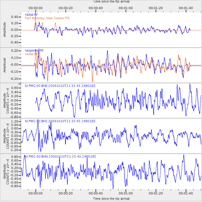
Signal To Noise
| Channel | StoN | STA | LTA |
| IU:PMG:00:BHZ:20091010T21:33:43.248018Z | 1.9607756 | 7.061842E-7 | 3.6015552E-7 |
| IU:PMG:00:BHN:20091010T21:33:43.248018Z | 0.8627222 | 3.190785E-7 | 3.6985082E-7 |
| IU:PMG:00:BHE:20091010T21:33:43.248018Z | 1.2322007 | 3.4781033E-7 | 2.822676E-7 |
| Arrivals |
| Ps | |
| PpPs | |
| PsPs/PpSs | |


