You are here: Home > Network List > IC - New China Digital Seismograph Network Stations List
> Station LSA Tibet, China > Earthquake Result Viewer
LSA Tibet, China - Earthquake Result Viewer
| Earthquake location: |
Banda Sea |
| Earthquake latitude/longitude: |
-7.0/129.0 |
| Earthquake time(UTC): |
1998/11/09 (313) 05:30:14 GMT |
| Earthquake Depth: |
33 km |
| Earthquake Magnitude: |
6.1 MB, 6.7 UNKNOWN, 6.6 ME |
| Earthquake Catalog/Contributor: |
WHDF/NEIC |
|
| Network: |
IC New China Digital Seismograph Network |
| Station: |
LSA Tibet, China |
| Lat/Lon: |
29.70 N/91.15 E |
| Elevation: |
3789 m |
|
| Distance: |
51.5 deg |
| Az: |
316.96 deg |
| Baz: |
128.854 deg |
| Ray Param: |
0.067312695 |
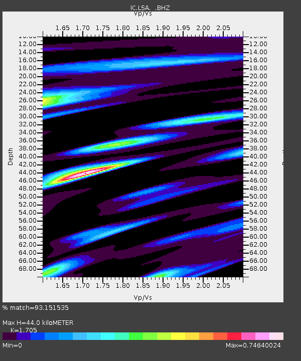
| Estimated Moho Depth: |
44.0 km |
| Estimated Crust Vp/Vs: |
1.71 |
| Assumed Crust Vp: |
6.514 km/s |
| Estimated Crust Vs: |
3.821 km/s |
| Estimated Crust Poisson's Ratio: |
0.24 |
|
| Radial Match: |
93.151535 % |
| Radial Bump: |
400 |
| Transverse Match: |
89.65333 % |
| Transverse Bump: |
400 |
| SOD ConfigId: |
4480 |
| Insert Time: |
2010-03-04 22:53:36.225 +0000 |
| GWidth: |
2.5 |
| Max Bumps: |
400 |
| Tol: |
0.001 |
|
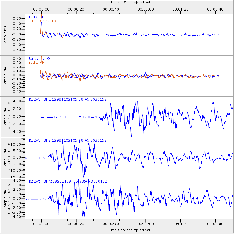
Signal To Noise
| Channel | StoN | STA | LTA |
| IC:LSA: :BHZ:19981109T05:38:46.303015Z | 12.127823 | 8.1028253E-7 | 6.681187E-8 |
| IC:LSA: :BHN:19981109T05:38:46.303015Z | 2.8647869 | 1.6404643E-7 | 5.726305E-8 |
| IC:LSA: :BHE:19981109T05:38:46.303015Z | 5.150327 | 2.5361052E-7 | 4.924163E-8 |
| Arrivals |
| Ps | 5.1 SECOND |
| PpPs | 17 SECOND |
| PsPs/PpSs | 22 SECOND |


