You are here: Home > Network List > IC - New China Digital Seismograph Network Stations List
> Station LSA Tibet, China > Earthquake Result Viewer
LSA Tibet, China - Earthquake Result Viewer
| Earthquake location: |
Flores Region, Indonesia |
| Earthquake latitude/longitude: |
-8.9/123.5 |
| Earthquake time(UTC): |
1997/01/17 (017) 11:20:22 GMT |
| Earthquake Depth: |
111 km |
| Earthquake Magnitude: |
6.2 MB, 6.2 UNKNOWN, 6.2 MW |
| Earthquake Catalog/Contributor: |
WHDF/NEIC |
|
| Network: |
IC New China Digital Seismograph Network |
| Station: |
LSA Tibet, China |
| Lat/Lon: |
29.70 N/91.15 E |
| Elevation: |
3789 m |
|
| Distance: |
49.4 deg |
| Az: |
322.159 deg |
| Baz: |
135.836 deg |
| Ray Param: |
0.068334855 |
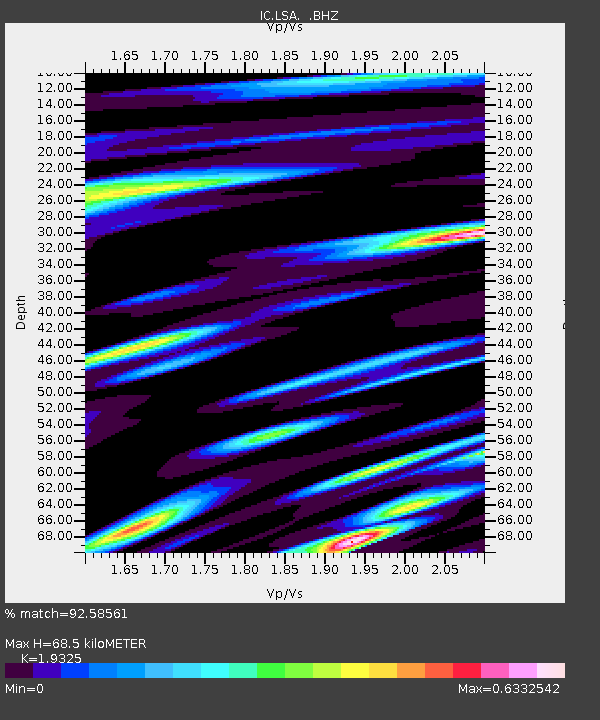
| Estimated Moho Depth: |
68.5 km |
| Estimated Crust Vp/Vs: |
1.93 |
| Assumed Crust Vp: |
6.514 km/s |
| Estimated Crust Vs: |
3.371 km/s |
| Estimated Crust Poisson's Ratio: |
0.32 |
|
| Radial Match: |
92.58561 % |
| Radial Bump: |
400 |
| Transverse Match: |
90.205185 % |
| Transverse Bump: |
400 |
| SOD ConfigId: |
4480 |
| Insert Time: |
2010-03-04 22:53:38.558 +0000 |
| GWidth: |
2.5 |
| Max Bumps: |
400 |
| Tol: |
0.001 |
|
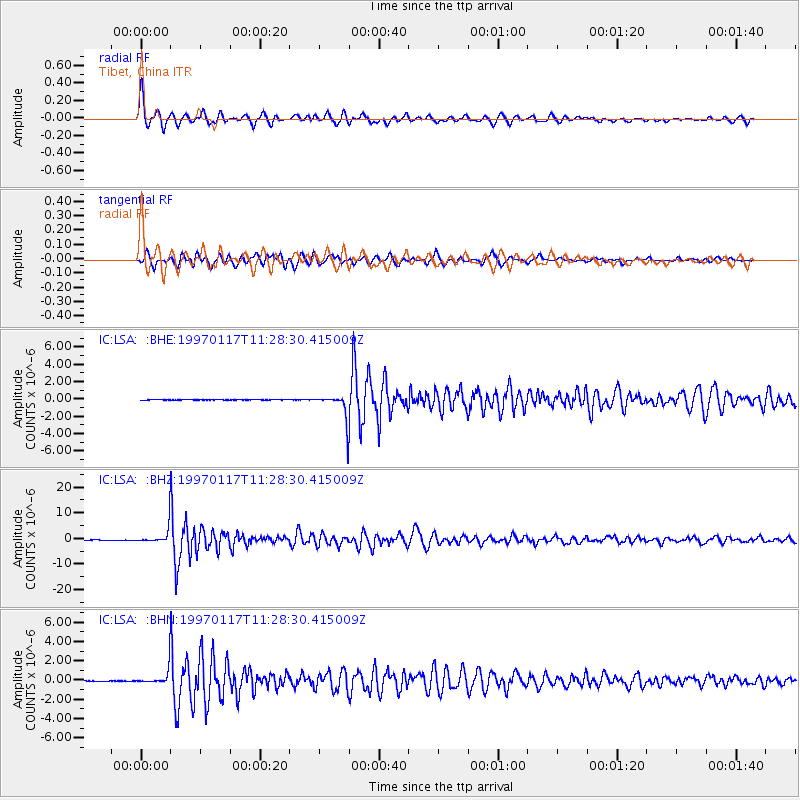
Signal To Noise
| Channel | StoN | STA | LTA |
| IC:LSA: :BHZ:19970117T11:28:30.415009Z | 67.77955 | 3.597906E-6 | 5.3082477E-8 |
| IC:LSA: :BHN:19970117T11:28:30.415009Z | 44.73972 | 9.347312E-7 | 2.0892648E-8 |
| IC:LSA: :BHE:19970117T11:28:30.415009Z | 44.50395 | 9.53088E-7 | 2.1415808E-8 |
| Arrivals |
| Ps | 10 SECOND |
| PpPs | 29 SECOND |
| PsPs/PpSs | 40 SECOND |


